So, I am not dead. Some people apparently wondered if I was. I only want to say that clearly I do not make this blog a priority, but if you like my writing style and kooky stories and trip reports, I tend to post the better ones over at www.summitpost.org now, under the User Name of "Andrew David". I am able to post as many pictures as I want there for free. I still cannot quite find the enthusiasm to pay $25 per year to stick pictures up here on a site very few visit, but when I get a better website up, I may do so again.
I gave up on selling photos for now as I am back in school learning some tech skills for programming Websites. That seems more profitable, so I am focused right there and will try the photo hobby thing again when I get more spare time.
I work as a trip organizer now with "Backpacker's Anonymous" through www.meetup.com. My trips are free and they are awesome. You can come join me sometime for a little social mountaineering. I do some exploring off trail and a little un-roped climbing still. One day I want to work as a guide on weekends, so I am getting experience now and making contacts. I needed some friends anyway and I have no idea how else to make them. Its been fun.
I will try listing some stories here with a link to a Facebook photo album of the trip soon. That remains free for me, and free is a huge feature of blogging as a hobby. I don't know if that will appeal to anyone, but maybe it will get my quiet little Facebook page humming.
Wishing great adventures on everyone out there,
Andrew David of "The Still Wild West"
P.S. I deleted several of my old whiniest posts.
Wednesday, October 9, 2013
Thursday, October 4, 2012
Loose Threads Sewn Together or Rolled into a Ball
Photos of Montana are posted elsewhere. An update on money in photography. I go over my training methods which I think quite good.
I will probably return to writing here soon, but I am still trying to resolve myself to a world where I will be paying a small fee to blog. I mean, its blogging, you know? But $2.49 to post all these photos so people may view them and read my adventure stories if they like is not bad. I enjoy it a little I suppose, in a vanity sort of way, few readers though I find.
I have had a little trouble with this blog in that I never feel witty or entertaining. Perhaps I let loose my inner cynicism too much, or I rush through posts trying to remember details before they fade and tell every story for every mile, or maybe its something else. Maybe I am entertaining. But I know that while writing letters by hand to people and sealing them in envelopes, I feel darned brilliant and recipients treasure these letters and all but beg me for more. I also always feel clever in emails, though they run long, and the dearth of replies perhaps suggests that I exhaust people or am not as entertaining as I think. My other blog all about food gets mostly rave reviews. I have more followers, and though I receive some criticism, my favorite comparing me to James Joyce without the payoff (a little like calling someone a torturer of teeth who fails to fill cavities), and a few death threats, mostly my fan response is gushing praise. Just peruse my fan letters and questions from real fans, which I can hardly keep up with in mailbag posts.
So I want to do better here. I think I can. I tell the same stories in person and in letters and am adored. Yet here, something does not click. I will work on that, and probably start paying to post a few pictures soon. For now, most of Washington is up here, but I did not post 4 final trip reports with photos. My Montana gallery on the website now has nearly 50 pictures up from 2 trips to Glacier National Park and some of them are really spectacular. Also I am working on posting to the Wyoming gallery. You can stop over there if you really love my pictures. Hey anything is possible.
Now for an update on my ongoing series: Is there money in photography? I am still finding the answer to be a hearty no. I receive more and more compliments and am trying different products, but even in an indoor, half-week show, I still sold very little. The posters fizzled, my cards were duds, and I moved not a single matte-framed print. A shock, as they are beautiful and all of these items I am practically trying to give away at this point. I am giving out more business cards and hearing more people say they will contact me, so maybe things are picking up. We'll see. The photos are good, and many unique, they are presented well, the price is good, I am not completely horrible to be around, but still no success so far.
Now for my workout theories. I used to spend most of my life in the gym. This was back in high school, during my bodybuilding days. That was probably a bad idea, but it gave me an excuse not to date, and I did win some contests and people guessed me to be 25 until my braces shone through a smile. I am not a gym rat anymore. I go once a week tops, and that is only in the winter. I try to do things at the gym that I can't accomplish outdoors. When weather is good, I walk anyplace under 2 miles, or skate, time permitting. Grocery store especially. Skating I use to keep my legs strong. That also utilizes many of the ski muscles, good for ski buffs. I never jog, as it hurts my knees, though I can walk and climb almost without end. Jogging puts a very high strain on the joints and I think there are wiser choices. If I am using machines for cardio during the winter, I go with a bike I can stand and climb on- simulating steep mountains, or any elliptical machine. There are also ski simulators, but I'd rather just go through that motion the few times I cross country ski each year (though this winter is looking good to be cold and long and snowy).
I prefer to get a lot of my work in in the pool. I alternate swimming, several strokes, with my favorite secret exercise: running in waist high water. I go forward, backward, sideways, and mix in jumps. It is a great chest-pounder that really gets the heart going and will build strong legs, particularly in muscles you climb with. Stretching is important every morning, at least a few moves. I mix in some light yoga when I need to relax before I start the day or feel extra stiff or tight. I like calisthenics, such as lunges, which are great for the mountain climber as they really stretch and strengthen the flexor muscle in the upper center of the thigh, connecting to the hip. That's a trouble spot when going uphill for long stretches and I popped both of mine a few seasons back. Since then they have been a focus muscle for me and my left one is problematic. Lunges, and lots of quad and hamstring stretches have prevented any injury this year though.
I play some racquetball and I find it pretty good for total body fitness. My last session left me with burning triceps, shoulders, chest, back, and abdominals and worked up a healthy sweat. I got enough running in to make me breathe heavy for about two seconds.
I think rhythm is a bad thing with exercising. I like to mix in bursts of intense training with a period just long enough to relax again. New machines seem to feature this thinking with preset programs that alternate 1 minute of hard effort with 4 or 2 minute cycles of moderate work. I go a step further. I make 1 out of each 3 or 4 "intense" minutes a "black-out" minute. I take it to the very edge of feeling like my heart will explode. This method is said to burn more calories, build more muscle, and improve aerobic capacity more. I agree on all counts.
Try to work all your muscles and not get into ruts. If the workout is predictable, or you always use the same machine for the same time, you are doing no good. In my one workout each week during winter I try to focus on specific mountain principles too. I do not take water, I may wet my mouth at the drinking fountain, but that's it. I will train up to 4 hours with no water. That's the idea. I keep going even after tired, do not eat, take very short breaks, and try to use any trick I can think to build stamina. Its the marine method really. Get used to being tired, hungry, hot, and dried out, and if you can still do a thing then, you can do it any time. If you are willing to work past suffering, you stop suffering. Or derived from Dante: the way out of Hell is to all the way through Hell. The elusive thing about comfort is the more you try to make yourself comfortable, the less comfortable you'll be. Its quite contrary to the concept in vogue now of sipping water constantly and snacking non-stop, to keep hydrated and nourished. It makes babies of men, I say. There's been plenty of chat about that on previous blogs.
I do little weight lifting. When I use weights, its with perfect form. I've had too many injuries trying to move great poundage. Its not practical strength either. In high school I could throw about huge weight, but I am probably stronger in a real world sense now. Its also not in my interests to weigh a ton anymore. I have trouble keeping a modest body weight with my metabolism and all the hiking I do. For strength training I prefer calisthenic type work at home. Stretch bands, pushups, planking, lunges, kicks, pullups. Those are great because they work with your bodyweight and in the mountains, that is what I need to move. They also produce real strength, the kind a gymnast has. When I do weights, I prefer free weights and sets of 12 reps. Again, keep perfect form. These do compliment the fuller range of motion of fitness bands and will build strength in core muscles that calisthenics cannot reproduce.
All of this worked well for me. In the whole summer I was often miserable, tired, hot, clumsy with fatigue, cursing, cold, or any other state, but on the whole, I put in a lot of long days of 12-13 hours with no injuries, little rest, day after day, and completed near 500 miles this year, most in the mountains, 300 in a 4 month period, and summited 47 peaks, many quite difficult. My troubles never compared with what I felt in previous seasons. Looking back at my hiking in the past, its laughable that I thought myself hard or strong. I turned back only a few times this year, was durable in all weathers, went whole days on sips of water or handfuls of meagre fare, and did what most would not even dream of, what most would call crazy. My suffering was never deep or prolonged. And the free and wild pleasures of the mountains, I was able to enjoy more than ever because they were not mingled with grief, grumbling, and pain or burns. If my adventures sound fun to you, you may want to try training like me. Older posts had some of this all in them too, but I wrote on it again because I tested myself all summer and fall and found my methods proved mostly true. I fully expect to be stronger, fitter, and harder next year and to have even less problems. Fluke things can occur, falling rocks and weather and the like, but I get ever more confident that I can handle anything, or at least, survive it.
Monday, August 27, 2012
Away to Wyoming
I have more Washington photos, but they will have to wait. I am off for another 3 weeks if all goes well to Wyoming first and then Montana. I am not sure what I am doing yet in Montana, and will decide that based on how I feel and what the weather is like and what looks good. All I know for certain is that I am going to the Wind River Range first, and the Big Sandy Trailhead, and then will do the Tetons at some point, hopefully 3-4 peaks there. I may go back to Glacier, and I may stay in southern Montana.
My disgusting quest to gain 12 pounds in 10 days so I have weight to lose when I start burning calories like crazy stalled out at about 6 pounds gained, though tomorrow is another day. I had to stop eating for tonight as I feel sick. I've been mixing in junk food and good stuff, which is the key to real weight gain. I know Americans are all wondering: how can I gain weight? So I will detail that sometime. I will have to resort to fast food and soda on this next trip. Drinking water is not going to cut it if I want to come back a Bane and not a skeleton. So for my very few fans who check this, I should be back on the 16th or 17th of September and I will probably post a few good pictures. And then I will catch up with my last 3 hikes for Washington, and post a few more to Artist's Point.
This next trip may have to be it. If I do all I want, that will be over 40 mountains in a 3 month period and that is probably approaching the limit of the human body's engineering, specifically what knees can take without regrettable permanent damage. And every good thing does stop being fun eventually. Take care all and enjoy life, and so forth. If I'm not mauled by a grizzly, I'll have some stories to tell.
Sunday, August 26, 2012
Artist's Point
The aptly-named endpoint of the Baker Highway 542 is a must-hike spot if you are ever in northern Washington.

Starting at Bellingham, WA, home of the historic Fairhaven district, which I am in love with, as detailed on www.youngbrokeandclueless.blogpspot.com, my other blog all about food, goes around 60 miles (depending on where you count it as starting) through small agrarian communities first, home to fruit farms, wineries, and the like, and offers pretty farm scenery and then pretty mountain scenery. Hiking opportunities are spaced out and abundant, with mountain peaks and ridgelines, forest hiking along a turquoise river, and of course, the mountain splendor around Artist's Point. I drove in after a good meal and a relaxing afternoon to spend the night in my car, or out on a trail somewhere. I had no real plan in place but intended to scope out Mt Baker as a potential spot and expected to climb Mt Shuksan, a spectacular and fierce mountain I have seen pictures of, much taller than anything else in the area, other than huge Mt Baker, which is more of a routine straight smooth glacier run. Storms were swirling all around, nothing threatening, but all a bit ominous and so several possibilities for that afternoon were off the slate. I stalled for a good hour by taking the trail at Horseshoe Bend along a pretty shining river, glittering like a diamond in the sun as clouds swallowed the tops of all the peaks around me. The trail is easy and flat for a mile, and then starts climbing. Most people quit at the mile, and I advise that too. If you want to go up steep hills, do it someplace where the final payoff will be a mountain with views. The area made me less enthused to go see rainforests, because between Horseshoe Bend and and Ohanapecosh at Mt Rainier, I was pretty sure I'd seen two of the prettiest short forest hikes possible on this earth.


Also nearby to this trail are Nooksack Falls, along an easy and good dirt road. Well worth a short side trip. Many of the following pictures were illegal, because "no trespassing" signs are posted all over this area as the cliffs are slippery and people have a tendency to fall off them. But I figured what is dangerous for other people is not for me and did what I wanted. I thought the cliffs were quite reasonable to walk around, as long as you don't try climbing over the fence to reach them.


Church Mountain, which requires a drive along a steep and rugged dirt road and is not much of a mountain. Skip it if you want my advice. And there is Excelsior Peak and Ridge, another not too impressive mountain that can be accessed from pavement, making it more palatable. The views should be good if you aren't too spoiled from other better views in your life, as I am. I skipped that trail too, in favor of Goat Mountain a few days later, which was probably a worse trail and worse views. Goat Mountain is along a gravel road of pretty good quality, though it is narrow, and given that it is in Washington and involves Washington drivers, you take your life in your hands to go anywhere near it. Hiking down Goat Mountain, one of my least favorite hikes in all my life, the highlight of the day was being 200 feet above the road, almost back down around noon, when I saw an SUV and a Subaru Outback both speeding recklessly and not paying attention as they nearly smashed into one another. My schadenfreude (spelled that right on the first try; yet I can't spell in English!) would have been dampened when I realized however that I was now trapped in the area until tow trucks and ambulances could be found to clear the wreckage out of my way. So happily, the two just squealed their breaks, looked at one another with pure Pacific Northwest hatred and holier-than-thou-itude, and then backed up at the same time until one of them found a pullout and that was that. Goat Mountain trail goes up an ungodly number of switchbacks, probably at least 100, through a dry, ugly forest with a ton of avalanche debris, no creek crossings larger than a trickle, on a narrowing trail, which gives way after miles to a hideous and sun-exposed section of brush, and meadowy-crud, where there are more insects than I thought the universe held. At no point is the trail pleasant or fun, and even on top, you are just on a shelf of a mountain, a long way from the several summits of the true massif, which I knew going in. I planned to bushwhack up the rest of the way to a real summit and thought from my recon the day before and photos I snapped that this would involve climbing on good real rock slabs and walls. But I must have had a wrong guess about where Goat Mountain trail fed out. The bushwhack is, either impossible, or nearly so, and would be a torture hardly worth it, I am sure. How much would you pay in your own blood and sweat for a view into Canada to the North? I wasn't willing to waste the next 6 hours going a mile and back to find out, and I am sure the ugly squat bushes and pine trees are happy with my choice. The view from Goat Mountain is bad, and as far as I can guess, the reason "everyone" (the info desk ladies' word when they successfully talked me out of a suicide run up Shuksan which was quivering with avalanche snow) is that the trail was melted out while better trails were not. As a public service gesture, I beg you: do not waste your time and knees on Goat Mountain! The trail was so vile that I kept shaking my head over it for days. Every time the rest of the week I was tired, I would ham it up Charlie Chaplin kicking a pebble style and sulk: "I'd still have some knees and pop in my calves if not for Goat Mountain."
Excelsior Peak will probably be similar, with long and plentiful switchbacks up a steep hill covered with trees. This is the only way the trails can be done, but its a high toll to pay just to make a mountaintop, as you go back and forth, with no views to replenish your stores of energy or inspire you to keep going, and with no hope of any variety. Forests are forests, but when you zig zag past the same pocket of trees for an hour, slowly gaining altitude and sweating through your clothes, its worse than ever. The Excelsior Ridge and Peak will be a payoff though, as you can follow the ridge 2+ miles and descend a different route if you like, though that would mean walking back to your car along the highway for a few miles. You would see all the Canada peaks to the North and especially some impressive peaks nearby in Washington, namely Mt Tomyhoi, Mt Larabee, the Pleiades, and Winchester Mountain, with an official trail and overlook, that would offer spectacular views. Tomyhoi and Larabee involve bushwhack approaches and will be climbs, only for "professionals" or the serious and experienced mountaineer. These peaks are accessed from the Twin Lakes area, accessible only by dirt road, and bad steep dirt road at that. It will require 4 wheel drive, and a true high clearance vehicle, not a toy SUV like a Honda CR-V, or the yuppie Subaru Outback which for all its promotion as a compromise between sedan and off-roader, is a joke in Colorado, according to message boards I've read by the serious dirt roaders and gets only a scant precious few inches more clearance than my very low Toyota Camry. The road was instantly and obviously nasty to me, and I did not try it. The info desk women assured me it was terrible and that the only person they'd heard from recently was a Jeep Wranger owner who had turned back because he was bottoming out and the road was too rugged! A Wranger! People put up with 15 miles per gallon and bad performance in all road conditions and poor reliability with frequent breakdowns just so they can take terrible dirt roads, so how bad is this road!? Its a shame either way as I would have loved to go up to that area, and still would. Its an awfully long dirt road to walk though. Looks like a good 15 miles at least on my map, and I lean closer to 20.


Artist's Point was my only payoff for the whole road then. The trail to Lake Ann, from which I planned to climb Shuksan was totally snowbound, with the lake still frozen. This was surprising and apparently is not common, which goes to show, that even in an average snow year, there will always be spots that take a dumping. Shuksan's cliffs and glaciers were not in condition and were quite obviously ready to avalanche. Even novices and stoners looking out at it could see this. I actually doubted whether the lake was completely frozen as most hikers will report a lake as "frozen" if it is not completely melted, clear of snow on the banks, and warm enough to swim in, and info people do not know the difference. My info ladies were very nice older ladies, clearly not mountaineers, and I suspected the lake might be at least part-melted, but still, the route looked bad. I have since discovered that at least several groups have made the climb I was intending in July and August, with online trip reports I've sniffed out. However, their list of gear is staggering and just the bolts and screws they used would have weighed more than all my pack. Going in teams, they used dual ice axes, double plastic boots ($400 usually), rope, anchors, ice screws, and every other kind of toy ever invented. The description also makes it clear I would have been over my head, solo. Sure I could have climbed it probably, had I not been killed in any avalanches (ice falls as loud as bombs/trains, and crevasses/moats, etcetera were mentioned in all reports), but coming down 4000 feet of mixed cliffs and glaciers would have been danged hard to not cliff out repeatedly, end up lost, trapped, or just down in the wrong area. Probably would have been exhaustive, frustrating, and not a good part of a balanced and prolonged mountain trip. But maybe someday, I will go solo the thing. These guys were all apparently intimately familiar with the route, in standard rock climber ways, having the whole thing broken down by previous climbers.

Climbing today, as I've mused before, is an odd business. Or hobby. The approach people take is largely that of scientists doing research. A doctor does not just start doing research without first reading all the current journals to know what has been done, discovered, etcetera. And no one would announce results before knowing if they just "discovered" something or were confirming another's research. Climbers do the same. Any first ascent is like gold and honor. To that end, all these serious climbers could do a climb blindfolded by the time they actually get to a mountain, having studied it endlessly. They know every move so the danger is largely removed, or filtered, and the thrill is a lot like a roller coaster ride. Almost like being on a track. Part of this is to minimize risk of dying, I get that, but part too is so that at any point, a team can just say, go right 50 feet and know that no one has climbed this cliff, so if they do, its a variation route and they can get in a climber mag. I can understand that too, though to me it all feels way too competitive and desperate for recognition with a community. There are some like myself (I am sure others do this too) who just show up, take a glance, and go up, the way mountaineers used to, when they were drawing maps that did not exist, naming forests and peaks (badly too often) and then describing their routes to confirm they were really there and so others could follow. There is more purity to that than our era, and rather than shrug, or feel hopeless and give up the idea of primacy as lost to the world and everything discovered, I (and some others I am sure) have come up with a different solution: don't read the guide books, get lost, risk everything the first explorers and wild men did, and shun the real world. Don't brag to the magazines, or even read them. Just go out and enjoy mountains the original and a more natural way. I doubt I've done any first ascents, and if I have, I don't care. I don't feel that an individual challenge is comprehended by those who try to turn it into a competitive community thing. See I climb because I like and I like mountains. I could care less if anyone or everyone else does it. I mean partly I do feel that the world should be used and enjoyed, so I like going where others do not go, and I avoid crowds and all that, but my point is, I race myself, and if others happen to do the same mountains, fine. The point is its man verses mountain, or man and mountain, if you prefer the non-combative, not man verses man on a mountain. If I were the last man on earth, I'd still want to climb Mt Shuksan, because it looks fun, hard, and cool.
So, I gave up Mount Shuksan, the mountain I most wanted to climb on this whole trip, but oh well. Live for another day, and I did scout the area. Artist's Point is just a mile past the Lake Ann Trailhead and is just a parking lot with a bathroom. This year, somehow, there is a huge amount of snow left. Here is the bathroom:

And here is the parking lot as I left to go climb Table Mountain, most people starting home for the night:

Artist's Point has trails in every direction, though this time they were all hidden in snow, but that did not stop people, even women in sandals, from going up the overlook mountains. And trying to "boot" sled down. For once in Washington I was not mocked for my gear or preparedness and as I trudged along safely in crampons, most were impressed and envious that I had such things, and a few asked to look at them and were surprised cleats can be purchased to go over regular shoes. I grabbed the same peak as everyone else, though I went farther, caught a family with a scared little girl, and impressed her as to the lack of danger in our situation by goat leaping down the slopes right next to them, putting distance between us quickly. She still seemed scared though the brother little boy I think wanted some ice cleats right then and there as I bounded away from them like a jumping flea on the ice. Sandal woman who made it all of 1 foot before falling on her slide attempt at the instigation of her boyfriend type was also a little pissed by my running/bounding past at Usain Bolt speed.


Next up I axed and climbed my way up a steep snow slope to Table Mountain, finding when I got near the top there is a walking trail all the way up and mostly out of the snow on the South side of the mountain. Now you know. Luckily I didn't come sweating and heaving over the edge of the peak to find boy scouts looking at me like a lost fool. I took the easy trail on the way down. But I explored the long and flat rolling summit of Table first. It goes for several miles and I had a great hike of it late evening as the sun was starting to set, with clouds all around, getting darker and swirling and swallowing mountains. This would all have been pretty dangerous had the parking area not been so nearby. But it looks dangerous in the pictures. I had Table to myself. I scouted mountains for next day and there were good possibilities in every direction, pretty mountains and trails to passes or else lots of snow to do what I wanted over. I slept in the car, inside a cloud, though it did not snow, and had I admit, a complete freak out. Coming back from the bathroom at one point around 2 am, I saw a shadow, thought it was a bear chasing me, ran by instinct a few feet, then stopped myself and faced it, before I realized how silly I was being. My flight instinct was triggered so easily because I'd not carried my knife or axe or baton to the bathroom with me and a man stands little chance against even a small bear bare-handed. Later in the morning a truck with trailer pulled up and some man felt the need to come over and look in on me sleeping. Probably he wanted to make sure I was okay, but I switched the window my head was under so if he came back to shoot me he'd only get my feet and I could see him coming, which means I'm either a complete paranoid, or that I have a natural marine's mentality. You can decide for yourself (and perhaps both are true; though that means you must sleep easy at night knowing that our nation's most paranoid are protecting us).

 In the morning I felt worn down and told myself to take it easy. With that in mind as I put boots on, though I took my pack with out onto the ice to snap quick sunrise photos of Mt Baker, I did not change my clothes, and stayed in my thermal long underwear and sleeping shirts. But the usual happened and once I was moving, I felt as strong as an elephant and wanted to go just a little further. Soon I was changing under a tree and going commando, down to a white tee shirt and without any water was making good time along the Ptarmington Ridge trail, which was mostly snow. I kept going just a little further and then gave it up and decided I was just doing it all. The trail ends at a peak that looks like the prow of a sinking ship, Coleman Pinnacle, though as I'd not studied or brought my map, I was calling it "Ptarmington Prow" as I went, and not only did I get there, but kept going, traversing another mile of glacier to target a mountain slightly taller at the end of the whole ridge, and forming a cirque to the north. I'd seen it the night before and figured it would make for a good, but long day. Now I was almost here. Baker was still far away and had that quality of many large mountains of looking farther away the closer I got. The approach from Artist's Point would be a two day affair, at least, and the way was crevassed heavily this time of year, so I gave it up content enough as I'd never planned on doing Baker anyway. Shuksan was my grief. The mountain I targeted I've mentioned already. I named it "Mt Lava Forest" and your options to reach the summit are: approach from the North and take a ridge of snow all the way (this is only reasonably done from Ptarmington Ridge trail and would involve a couple extra miles of traverse around unpleasant and even sketchy slopes, either snow or scree, depending on conditions, or: don't make the summit. From the South, it cannot be reached, short of chain saw, flame thrower, or incredible amount of grit and stupidity. You have a choice of rotten and deadly lava cliffs, all overhanging, fall and slide prone and terrible if not impossible to climb, and a brushy pine forest so dense you are walking on pine branches, getting coated with sticky pissed-off tree sap (oh yes trees can get pissed off and if you don't believe me, just kick one until it starts oozing at you sometime), poked, torn, tripped, snared, and making no progress whatsoever, while damaging a fragile ecosystem. The view from "Little Lava Forest" just South is just as good and count it as the mountain and move on with your life. Below the view towards Mt Lava Forest from Little Lava Forest and my first "crevasse". A little hollowed out channel I had to hop over on the snow.

 I got back to the parking area around 2 pm, very dried out from having no water still as I'd never crossed any, though I'd been mouthing snow the last few hours to keep from getting so cotton-mouthed I could not swallow. I kid you not: I came over a snow crest to find the parking lot very changed and very full:
And on this hill, spontaneously or led by ranger- I cannot guess- people were holding hands and singing that Charlie Brown Christmas song, where they all tilt their heads to the sky and go ooo-ooooo-ooooooo- you know the one, I can't very well write it out, there are no words, just a sort of melody, and at this shining time of day and with so many people it was like walking into a scene at the end of "How the Grinch Stole Christmas". I thought I was tripping out. And then some people were asking me about trails, and if there were any, and where they were. I pointed at the snow, and said, 10 feet under you, you're on it. Which pleased them well as they'd thought they were lost.

Other potential trails in this area are Bagley Lakes or Chain of Lakes, both of which lead very close to the summit of a pretty mountain north of Table Mountain across a cirque named Mazama Dome which I almost climbed, but I'd already done several peaks and how much were the views going to change in this area? The peak would involve a final rough and serious scramble or climb, up snow and rock, but could be done by anyone fit and a little daring. If you get the shakes ever or routinely, probably content yourself with the saddle. Official campgrounds are near Table Mountain and Mazama Dome though either is within a few miles of parking in several directions. Panorama Dome is very close to the start of the Lake Ann Trail and could be done any season even if the trail is buried. If you can't figure out the route, then you should not even be driving in the mountains. Its pretty straight forward. Good pictures can be had from anywhere, even the bathroom in the parking lot at Artist's Point. In winter this is all a ski area. Mt Baker is climbed most commonly from the end of a good dirt road Number 39 accessed from the 542, though I never saw the turn off. Apparently no one climbs it from the end of the 542- the way is too long- one of the nice older ladies of the info desk said this to me as if everyone in Washington knew this but me. They were impressed I'd even gone along the Ptarmington Ridge. "No one goes out there," they assured me. I saw lots of goat tracks everywhere, but no goats. Goat Mountain as mentioned is hideous and unworthy, and I also scouted the "Nooksack Cirque trail" and was not enthused. The road is bad with no way to turn around once on it, and the parking area is prone to break ins, with the trail requiring a lot of stream fording, and I doubt, though I did not take it, offering any stellar views. But the road is gentle enough to take any car up. I saw one man pulled over with a blown-up radiator much worse than mine from Montana, but if you don't run your air conditioner on high while going up the road, you should be okay. And when finished, go eat in Fairhaven, its a dream! And if you put a good hike in, you can eat whatever you want and not gain weight.

Starting at Bellingham, WA, home of the historic Fairhaven district, which I am in love with, as detailed on www.youngbrokeandclueless.blogpspot.com, my other blog all about food, goes around 60 miles (depending on where you count it as starting) through small agrarian communities first, home to fruit farms, wineries, and the like, and offers pretty farm scenery and then pretty mountain scenery. Hiking opportunities are spaced out and abundant, with mountain peaks and ridgelines, forest hiking along a turquoise river, and of course, the mountain splendor around Artist's Point. I drove in after a good meal and a relaxing afternoon to spend the night in my car, or out on a trail somewhere. I had no real plan in place but intended to scope out Mt Baker as a potential spot and expected to climb Mt Shuksan, a spectacular and fierce mountain I have seen pictures of, much taller than anything else in the area, other than huge Mt Baker, which is more of a routine straight smooth glacier run. Storms were swirling all around, nothing threatening, but all a bit ominous and so several possibilities for that afternoon were off the slate. I stalled for a good hour by taking the trail at Horseshoe Bend along a pretty shining river, glittering like a diamond in the sun as clouds swallowed the tops of all the peaks around me. The trail is easy and flat for a mile, and then starts climbing. Most people quit at the mile, and I advise that too. If you want to go up steep hills, do it someplace where the final payoff will be a mountain with views. The area made me less enthused to go see rainforests, because between Horseshoe Bend and and Ohanapecosh at Mt Rainier, I was pretty sure I'd seen two of the prettiest short forest hikes possible on this earth.


Also nearby to this trail are Nooksack Falls, along an easy and good dirt road. Well worth a short side trip. Many of the following pictures were illegal, because "no trespassing" signs are posted all over this area as the cliffs are slippery and people have a tendency to fall off them. But I figured what is dangerous for other people is not for me and did what I wanted. I thought the cliffs were quite reasonable to walk around, as long as you don't try climbing over the fence to reach them.


Church Mountain, which requires a drive along a steep and rugged dirt road and is not much of a mountain. Skip it if you want my advice. And there is Excelsior Peak and Ridge, another not too impressive mountain that can be accessed from pavement, making it more palatable. The views should be good if you aren't too spoiled from other better views in your life, as I am. I skipped that trail too, in favor of Goat Mountain a few days later, which was probably a worse trail and worse views. Goat Mountain is along a gravel road of pretty good quality, though it is narrow, and given that it is in Washington and involves Washington drivers, you take your life in your hands to go anywhere near it. Hiking down Goat Mountain, one of my least favorite hikes in all my life, the highlight of the day was being 200 feet above the road, almost back down around noon, when I saw an SUV and a Subaru Outback both speeding recklessly and not paying attention as they nearly smashed into one another. My schadenfreude (spelled that right on the first try; yet I can't spell in English!) would have been dampened when I realized however that I was now trapped in the area until tow trucks and ambulances could be found to clear the wreckage out of my way. So happily, the two just squealed their breaks, looked at one another with pure Pacific Northwest hatred and holier-than-thou-itude, and then backed up at the same time until one of them found a pullout and that was that. Goat Mountain trail goes up an ungodly number of switchbacks, probably at least 100, through a dry, ugly forest with a ton of avalanche debris, no creek crossings larger than a trickle, on a narrowing trail, which gives way after miles to a hideous and sun-exposed section of brush, and meadowy-crud, where there are more insects than I thought the universe held. At no point is the trail pleasant or fun, and even on top, you are just on a shelf of a mountain, a long way from the several summits of the true massif, which I knew going in. I planned to bushwhack up the rest of the way to a real summit and thought from my recon the day before and photos I snapped that this would involve climbing on good real rock slabs and walls. But I must have had a wrong guess about where Goat Mountain trail fed out. The bushwhack is, either impossible, or nearly so, and would be a torture hardly worth it, I am sure. How much would you pay in your own blood and sweat for a view into Canada to the North? I wasn't willing to waste the next 6 hours going a mile and back to find out, and I am sure the ugly squat bushes and pine trees are happy with my choice. The view from Goat Mountain is bad, and as far as I can guess, the reason "everyone" (the info desk ladies' word when they successfully talked me out of a suicide run up Shuksan which was quivering with avalanche snow) is that the trail was melted out while better trails were not. As a public service gesture, I beg you: do not waste your time and knees on Goat Mountain! The trail was so vile that I kept shaking my head over it for days. Every time the rest of the week I was tired, I would ham it up Charlie Chaplin kicking a pebble style and sulk: "I'd still have some knees and pop in my calves if not for Goat Mountain."
Excelsior Peak will probably be similar, with long and plentiful switchbacks up a steep hill covered with trees. This is the only way the trails can be done, but its a high toll to pay just to make a mountaintop, as you go back and forth, with no views to replenish your stores of energy or inspire you to keep going, and with no hope of any variety. Forests are forests, but when you zig zag past the same pocket of trees for an hour, slowly gaining altitude and sweating through your clothes, its worse than ever. The Excelsior Ridge and Peak will be a payoff though, as you can follow the ridge 2+ miles and descend a different route if you like, though that would mean walking back to your car along the highway for a few miles. You would see all the Canada peaks to the North and especially some impressive peaks nearby in Washington, namely Mt Tomyhoi, Mt Larabee, the Pleiades, and Winchester Mountain, with an official trail and overlook, that would offer spectacular views. Tomyhoi and Larabee involve bushwhack approaches and will be climbs, only for "professionals" or the serious and experienced mountaineer. These peaks are accessed from the Twin Lakes area, accessible only by dirt road, and bad steep dirt road at that. It will require 4 wheel drive, and a true high clearance vehicle, not a toy SUV like a Honda CR-V, or the yuppie Subaru Outback which for all its promotion as a compromise between sedan and off-roader, is a joke in Colorado, according to message boards I've read by the serious dirt roaders and gets only a scant precious few inches more clearance than my very low Toyota Camry. The road was instantly and obviously nasty to me, and I did not try it. The info desk women assured me it was terrible and that the only person they'd heard from recently was a Jeep Wranger owner who had turned back because he was bottoming out and the road was too rugged! A Wranger! People put up with 15 miles per gallon and bad performance in all road conditions and poor reliability with frequent breakdowns just so they can take terrible dirt roads, so how bad is this road!? Its a shame either way as I would have loved to go up to that area, and still would. Its an awfully long dirt road to walk though. Looks like a good 15 miles at least on my map, and I lean closer to 20.


Artist's Point was my only payoff for the whole road then. The trail to Lake Ann, from which I planned to climb Shuksan was totally snowbound, with the lake still frozen. This was surprising and apparently is not common, which goes to show, that even in an average snow year, there will always be spots that take a dumping. Shuksan's cliffs and glaciers were not in condition and were quite obviously ready to avalanche. Even novices and stoners looking out at it could see this. I actually doubted whether the lake was completely frozen as most hikers will report a lake as "frozen" if it is not completely melted, clear of snow on the banks, and warm enough to swim in, and info people do not know the difference. My info ladies were very nice older ladies, clearly not mountaineers, and I suspected the lake might be at least part-melted, but still, the route looked bad. I have since discovered that at least several groups have made the climb I was intending in July and August, with online trip reports I've sniffed out. However, their list of gear is staggering and just the bolts and screws they used would have weighed more than all my pack. Going in teams, they used dual ice axes, double plastic boots ($400 usually), rope, anchors, ice screws, and every other kind of toy ever invented. The description also makes it clear I would have been over my head, solo. Sure I could have climbed it probably, had I not been killed in any avalanches (ice falls as loud as bombs/trains, and crevasses/moats, etcetera were mentioned in all reports), but coming down 4000 feet of mixed cliffs and glaciers would have been danged hard to not cliff out repeatedly, end up lost, trapped, or just down in the wrong area. Probably would have been exhaustive, frustrating, and not a good part of a balanced and prolonged mountain trip. But maybe someday, I will go solo the thing. These guys were all apparently intimately familiar with the route, in standard rock climber ways, having the whole thing broken down by previous climbers.

Climbing today, as I've mused before, is an odd business. Or hobby. The approach people take is largely that of scientists doing research. A doctor does not just start doing research without first reading all the current journals to know what has been done, discovered, etcetera. And no one would announce results before knowing if they just "discovered" something or were confirming another's research. Climbers do the same. Any first ascent is like gold and honor. To that end, all these serious climbers could do a climb blindfolded by the time they actually get to a mountain, having studied it endlessly. They know every move so the danger is largely removed, or filtered, and the thrill is a lot like a roller coaster ride. Almost like being on a track. Part of this is to minimize risk of dying, I get that, but part too is so that at any point, a team can just say, go right 50 feet and know that no one has climbed this cliff, so if they do, its a variation route and they can get in a climber mag. I can understand that too, though to me it all feels way too competitive and desperate for recognition with a community. There are some like myself (I am sure others do this too) who just show up, take a glance, and go up, the way mountaineers used to, when they were drawing maps that did not exist, naming forests and peaks (badly too often) and then describing their routes to confirm they were really there and so others could follow. There is more purity to that than our era, and rather than shrug, or feel hopeless and give up the idea of primacy as lost to the world and everything discovered, I (and some others I am sure) have come up with a different solution: don't read the guide books, get lost, risk everything the first explorers and wild men did, and shun the real world. Don't brag to the magazines, or even read them. Just go out and enjoy mountains the original and a more natural way. I doubt I've done any first ascents, and if I have, I don't care. I don't feel that an individual challenge is comprehended by those who try to turn it into a competitive community thing. See I climb because I like and I like mountains. I could care less if anyone or everyone else does it. I mean partly I do feel that the world should be used and enjoyed, so I like going where others do not go, and I avoid crowds and all that, but my point is, I race myself, and if others happen to do the same mountains, fine. The point is its man verses mountain, or man and mountain, if you prefer the non-combative, not man verses man on a mountain. If I were the last man on earth, I'd still want to climb Mt Shuksan, because it looks fun, hard, and cool.
So, I gave up Mount Shuksan, the mountain I most wanted to climb on this whole trip, but oh well. Live for another day, and I did scout the area. Artist's Point is just a mile past the Lake Ann Trailhead and is just a parking lot with a bathroom. This year, somehow, there is a huge amount of snow left. Here is the bathroom:

And here is the parking lot as I left to go climb Table Mountain, most people starting home for the night:

Artist's Point has trails in every direction, though this time they were all hidden in snow, but that did not stop people, even women in sandals, from going up the overlook mountains. And trying to "boot" sled down. For once in Washington I was not mocked for my gear or preparedness and as I trudged along safely in crampons, most were impressed and envious that I had such things, and a few asked to look at them and were surprised cleats can be purchased to go over regular shoes. I grabbed the same peak as everyone else, though I went farther, caught a family with a scared little girl, and impressed her as to the lack of danger in our situation by goat leaping down the slopes right next to them, putting distance between us quickly. She still seemed scared though the brother little boy I think wanted some ice cleats right then and there as I bounded away from them like a jumping flea on the ice. Sandal woman who made it all of 1 foot before falling on her slide attempt at the instigation of her boyfriend type was also a little pissed by my running/bounding past at Usain Bolt speed.


Next up I axed and climbed my way up a steep snow slope to Table Mountain, finding when I got near the top there is a walking trail all the way up and mostly out of the snow on the South side of the mountain. Now you know. Luckily I didn't come sweating and heaving over the edge of the peak to find boy scouts looking at me like a lost fool. I took the easy trail on the way down. But I explored the long and flat rolling summit of Table first. It goes for several miles and I had a great hike of it late evening as the sun was starting to set, with clouds all around, getting darker and swirling and swallowing mountains. This would all have been pretty dangerous had the parking area not been so nearby. But it looks dangerous in the pictures. I had Table to myself. I scouted mountains for next day and there were good possibilities in every direction, pretty mountains and trails to passes or else lots of snow to do what I wanted over. I slept in the car, inside a cloud, though it did not snow, and had I admit, a complete freak out. Coming back from the bathroom at one point around 2 am, I saw a shadow, thought it was a bear chasing me, ran by instinct a few feet, then stopped myself and faced it, before I realized how silly I was being. My flight instinct was triggered so easily because I'd not carried my knife or axe or baton to the bathroom with me and a man stands little chance against even a small bear bare-handed. Later in the morning a truck with trailer pulled up and some man felt the need to come over and look in on me sleeping. Probably he wanted to make sure I was okay, but I switched the window my head was under so if he came back to shoot me he'd only get my feet and I could see him coming, which means I'm either a complete paranoid, or that I have a natural marine's mentality. You can decide for yourself (and perhaps both are true; though that means you must sleep easy at night knowing that our nation's most paranoid are protecting us).

 In the morning I felt worn down and told myself to take it easy. With that in mind as I put boots on, though I took my pack with out onto the ice to snap quick sunrise photos of Mt Baker, I did not change my clothes, and stayed in my thermal long underwear and sleeping shirts. But the usual happened and once I was moving, I felt as strong as an elephant and wanted to go just a little further. Soon I was changing under a tree and going commando, down to a white tee shirt and without any water was making good time along the Ptarmington Ridge trail, which was mostly snow. I kept going just a little further and then gave it up and decided I was just doing it all. The trail ends at a peak that looks like the prow of a sinking ship, Coleman Pinnacle, though as I'd not studied or brought my map, I was calling it "Ptarmington Prow" as I went, and not only did I get there, but kept going, traversing another mile of glacier to target a mountain slightly taller at the end of the whole ridge, and forming a cirque to the north. I'd seen it the night before and figured it would make for a good, but long day. Now I was almost here. Baker was still far away and had that quality of many large mountains of looking farther away the closer I got. The approach from Artist's Point would be a two day affair, at least, and the way was crevassed heavily this time of year, so I gave it up content enough as I'd never planned on doing Baker anyway. Shuksan was my grief. The mountain I targeted I've mentioned already. I named it "Mt Lava Forest" and your options to reach the summit are: approach from the North and take a ridge of snow all the way (this is only reasonably done from Ptarmington Ridge trail and would involve a couple extra miles of traverse around unpleasant and even sketchy slopes, either snow or scree, depending on conditions, or: don't make the summit. From the South, it cannot be reached, short of chain saw, flame thrower, or incredible amount of grit and stupidity. You have a choice of rotten and deadly lava cliffs, all overhanging, fall and slide prone and terrible if not impossible to climb, and a brushy pine forest so dense you are walking on pine branches, getting coated with sticky pissed-off tree sap (oh yes trees can get pissed off and if you don't believe me, just kick one until it starts oozing at you sometime), poked, torn, tripped, snared, and making no progress whatsoever, while damaging a fragile ecosystem. The view from "Little Lava Forest" just South is just as good and count it as the mountain and move on with your life. Below the view towards Mt Lava Forest from Little Lava Forest and my first "crevasse". A little hollowed out channel I had to hop over on the snow.

And on this hill, spontaneously or led by ranger- I cannot guess- people were holding hands and singing that Charlie Brown Christmas song, where they all tilt their heads to the sky and go ooo-ooooo-ooooooo- you know the one, I can't very well write it out, there are no words, just a sort of melody, and at this shining time of day and with so many people it was like walking into a scene at the end of "How the Grinch Stole Christmas". I thought I was tripping out. And then some people were asking me about trails, and if there were any, and where they were. I pointed at the snow, and said, 10 feet under you, you're on it. Which pleased them well as they'd thought they were lost.

Other potential trails in this area are Bagley Lakes or Chain of Lakes, both of which lead very close to the summit of a pretty mountain north of Table Mountain across a cirque named Mazama Dome which I almost climbed, but I'd already done several peaks and how much were the views going to change in this area? The peak would involve a final rough and serious scramble or climb, up snow and rock, but could be done by anyone fit and a little daring. If you get the shakes ever or routinely, probably content yourself with the saddle. Official campgrounds are near Table Mountain and Mazama Dome though either is within a few miles of parking in several directions. Panorama Dome is very close to the start of the Lake Ann Trail and could be done any season even if the trail is buried. If you can't figure out the route, then you should not even be driving in the mountains. Its pretty straight forward. Good pictures can be had from anywhere, even the bathroom in the parking lot at Artist's Point. In winter this is all a ski area. Mt Baker is climbed most commonly from the end of a good dirt road Number 39 accessed from the 542, though I never saw the turn off. Apparently no one climbs it from the end of the 542- the way is too long- one of the nice older ladies of the info desk said this to me as if everyone in Washington knew this but me. They were impressed I'd even gone along the Ptarmington Ridge. "No one goes out there," they assured me. I saw lots of goat tracks everywhere, but no goats. Goat Mountain as mentioned is hideous and unworthy, and I also scouted the "Nooksack Cirque trail" and was not enthused. The road is bad with no way to turn around once on it, and the parking area is prone to break ins, with the trail requiring a lot of stream fording, and I doubt, though I did not take it, offering any stellar views. But the road is gentle enough to take any car up. I saw one man pulled over with a blown-up radiator much worse than mine from Montana, but if you don't run your air conditioner on high while going up the road, you should be okay. And when finished, go eat in Fairhaven, its a dream! And if you put a good hike in, you can eat whatever you want and not gain weight.
Saturday, August 25, 2012
The Secret Garden
A pseudo trail provides high thrills in Olympic National Park's Sol Duc section. As always prints are available if you'd like any, and I clean up the colors on actual photos where needed.

 The Sol Duc area of Olympic National Park is very popular, so popular that there are quotas in place for backcountry camping which make it difficult to visit and enjoy the area. I found a good compromise to this by camping just outside the quota zone at Appleton Pass, a high elevation campsite 2.6 miles out of the way of the famous loop that takes in the High Divide Trail, often called "The High Divide Loop." My plan was to backtrack downhill 2.6 miles the next morning after camping and beat it out all in one day for the rest, but a better plan was suggested by a friendly and very helpful ranger at the Wilderness Info Center. He said there was a trail from Appleton Pass to the Catwalk which meant I need not backtrack. It was a footpath, but would be faint, disappear some, though the route would be intuitive. Also he found me a Sunday night slot at Heart Lake, which was great on short notice, and surprising. He advised me to use it and not try to make it all the way out in one day. Mileage-wise, it would have been okay, but I was glad for this advice as most of the trail is in the sun, especially the High Divide 2 mile section, and anytime after morning is brutal to be up there. People do it, but I do not personally know how they can enjoy it. But that is all in due time.
The Wilderness Info Center is extremely inconvenient in Port Angeles, WA, as Olympic National Park is sprawling and vast, but it is the only place to get permits for the quota areas so I drove 30 miles out of my way, and then 30 miles back to talk with them, and for the advice and trip planning aid I got, it was well worth the trip. I had a bad trip planned and my ranger friend provided me with a much more pleasant and rewarding experience thanks to their knowledge of the area. That is what rangers are for in my mind. Although more typically rangers exist to amuse tourists, and ensure their return with money. That can mean shooing bears, playing "junior ranger" with kids, and checking bathrooms for toilet paper and cleanliness. But helping actual real hikers and adventurers to enjoy wild land is probably a nice change of pace for them, maybe.
My trip began around noon at the Sol Duc trailhead. There is only one, from a huge parking area. 1 mile of easy and pretty trail gets you to a popular three-headed hydra of a waterfall, pretty and lush, and the views only partly marred by overlooks and structure. I saw a small rainbow while there in the morning mist, and got some other impressive and even stunning light effects between some trees, like this below:


 From the falls, I took the Sol Duc River trail about 4 miles slightly uphill over mostly easy soft, springy lush ground through very pretty forest with only occassional rocks. A few falls along the way are hard to view but impressive from afar. The trail will then fork, to the right is the common route along the High Divide Loop. Appleton Pass and campground await the traveller to the left, and so does a steep, surprisingly direct trail with few switchbacks (praise God!) and direct, hard lines up the sides of some sun-struck, hot slopes through much less pretty forest. A few mangy views from meadows and openings in the trees are best neglected. A few mudpots pass for ponds and are best skipped past quickly. A pretty creek crossing is mossy and sparkling like a trickle of diamonds at one point. Appleton Pass is 2.5 miles from the split, making for a 7.5 mile day from the TH, not bad, though it took most parties with a pack most of the day, as I passed a group of eight and the campground was empty from 3 pm when I got there until around dusk, when I was passing back down a ways to scramble up some ridge rocks for sunset photos.


Appleton Pass itself is dreary and uninspiring, though to the left moderately pretty Mt Appleton sits. The campground sprawls for 1/2 a mile towards and then past Oyster Lake, the only water source, to the top of an unnamed tableaux of a mountain that plateaus rather than peaks. The best views are from the final campsite, basically atop this mountain near a stunning field of wildflowers, but the walk for water will be long. A couple small sites are available at the lake and are perfect for the bivouac man, like myself. I tucked under some trees and gave myself a 2 sided shelter of thick brush, hid in the shade all afternoon, and tried to ignore the bugs who tried to ignore my bug spray. This made me all but invisible and it paid off when a family of three deer walked right up and I nearly got the best baby deer picture of all time, but my target turned from me and dropped a hoof he was scratching himself with so I had to settle for this:


Later in the evening a large elk came by also unaware of me. In the morning it was two adolescent male deer, brothers or best friends, who came trotting up for water before freezing when they found me at their favorite watering hole filtering for myself. The lake is central to the pretty flower field or the ridge near Mt Appleton that provides the best expansive sunset view. Sunrise I think would be a sorry affair with glare spots right in your lens or a blinding light stopping you from seeing much. A 10 minute scramble up the ridge along boot tracks will get you as good a view as another hour of climbing will. I went as far as willing with the hope of summiting Mt Appleton before realizing the brush was getting thick, the going slow, and the effort too much with diminishing returns. So I headed back down, took a few pictures, and missed the true alpine glow of glowing red peaks by 5 minutes. I gave up on the sunset too early and kicked myself, but still had some decent pictures.
 There is a chain of peaks in front and a chain of peaks behind,
much rockier, and more sombre-looking, in the left corner above. That second distant set of peaks
is The Baileys, often climbed, though not so easy to access. Though
easy by Olympic National Park mountain standards, I suppose. The
highest is Mt Carrie and was my hope for the next day. On the right corner background you see the real and true Mt Olympus the park is named after, accessible by a 17 mile river trail through a rainforest. The lots of glacier travel, best early in summer.
There is a chain of peaks in front and a chain of peaks behind,
much rockier, and more sombre-looking, in the left corner above. That second distant set of peaks
is The Baileys, often climbed, though not so easy to access. Though
easy by Olympic National Park mountain standards, I suppose. The
highest is Mt Carrie and was my hope for the next day. On the right corner background you see the real and true Mt Olympus the park is named after, accessible by a 17 mile river trail through a rainforest. The lots of glacier travel, best early in summer.
There are also flowers near the lake:
The charming pic above is centered around scenic but rugged to approach Mt Appleton.
Appleton Pass was much prettier than I hoped, though Oyster Lake was too small and partly frozen to swim in. But the hike in was not so hot as I expected and a little shade made me feel quite refreshed. I slept solidly, though deer were about me, and I was a little anxious about bears, because if I were a bear, I would live there, and I was already right on a deer highway. The rangers told me this night was the peak of a meteor shower, but when I got up a few times to relieve myself against some trees, I saw nothing but the usual few shooting stars, though there were a jaw-dropping number of stars above me, more than usual when I scan the wilderness heights above me. Or they just impressed me more this night. Temperature was wonderful around the middle 40s.
I got up early as I had a long day potentially, if I wanted to climb Mt Carrie. I felt good about taking this pseudo trail, not on the maps, now, as I had scouted it the evening before, but I did not want to miss the peak of the sunrise for the wildflower meadow. Got a later start than I wanted filtering water. But couldn't trust any of the water sources on the map this late in the summer. Made the meadows by a little before 6 which was just right. Maybe 5 minutes late, but still awesome:


And then when I was finished shooting the mountains I was heading through and over to reach a further set of peaks, I noticed a bear munching flowers a few hundred feet from the trail. This was near a campsite of a solo hiker so I tapped on his tent wall and pardoned myself to wake him, but "just to let you know, if you hear any noises, its a fully grown 350 lb blackbear just outside your camp eating flowers" I said. He was up in a hurry, but did not see the bear. After taking some pictures I did not want to spook my fluffy friend so I tapped 3 steady raps on a rock with my ice axe rap-rap-rap. The bear looked over at me with a quick head turn, did a double take freeze frame look of shock, and then loped at full gallop across the meadow away into the thickets. This brings me to a good point: do not summit the forested peak that Appleton Camp sits on. Count it as a mountain if you go up the flower meadow or take the trail past Oyster Lake as you are only a hundred feet or so from the high point and would have to pass through heavy ideal bear habitat to make the summit. I was smarter or lazier than usual and saved myself a mauling the night before, perhaps, by not going up there. Do the same, I suggest. My friend came out and thanked me for alerting him. I was glad he was not crabby and sorry I had chased off his bear. I never thought a grown bear would look at me from afar and run FROM me. That is not what the rangers or literature prepare you for. They make it sound like a bear will get spooked and come at you. I am pretty gruesome to behold though in the morning, I guess.
Headed along my trail, which crossed snowfields and disappeared quickly and several times. Big piles of bear scat abounded, and I was glad to know already where the bear was. A second was unlikely as they are solitary and territorial. I knew where the trail should go and where it wound up from the night before so trusted instinct and caught it again. The trail is evident usually and intuitive enough with perhaps some foraging and contemplation time. The trail is pretty all the way and cuts along the side of a peak in a small but pretty range of lush mountains. I named the peak where the trail hits a small pass, "Wildflower Mountain" and summited it. This was easy, though it is challenging not to crush flowers or bushes beneath your boots. Please take care if you go up to "Wildflower Mountain's" summit. There is no trail and few will have been up there before. The view is pretty and I think worth the diversion of a half hour. From there the trail traverses several other peaks, faint in places, but intuitive in that the trail cannot go anyplace else logically unless other mountaineers wanted to go down a steep 1,000 hill for no reason just to go up another in a half mile. So take your time looking around when in doubt and if there are several in your party, things are easy. Go in every direction and call when evidence of trail is found again. Alone, its harder. The trail stays good and easy, though in earlier summer, you will have more snow and ice to deal with. I fell on a bad ice field, though not badly. Just got my pants and hands wet. Eventually, after 3 miles or so, things get sketchier, fainter, steeper, rockier, bushwhackier, nastier, pokier, trippier, fallier, and generally unpleasant. The way stops being fun. I fell more in a mile than I have in my whole life I think, cut my hand, rolled ankles, cursed, muttered, got worn down, and then found myself in a rock scree field with no trail at all in sight and nothing obvious about where to go. I was in hot sun but stopped for water and to scan the map. The most sensible plan to me was to go to this lake near me which I thought must be on the map as Haig's Lake, anticipating that lakes always have trails to and from them worn down by hopeful fishermen with favorite secret spots. This logic worked out perfectly for me as from the lake to the Catwalk, which is on the map, and is a spur trail extension from the official High Divide trail, I never was in doubt again. I was in sun, in brush, on steep traverse slopes, hating the sudden scorched area, the ugly lake, the falling, and everything generally. I made the Catwalk and took a break.

Below is the view back along the first half of "The Secret Garden" trail. Taken from "Wildflower Mountain" summit (my name) looking back at Mt Appleton and the pass it shares with "Appleton Jr", or "Camp Peak"- take your choice of what to call the other mountain where the bear lives and the campsite actually sits.


 I decided this trail should be named "The Secret Garden Trail"
due to all the amazing flowers and pretty peaks you pass through, and
that is a good name too since it is not on the map, is not official,
maintained, or easy, and is only mentioned by the rangers if you
specifically ask, or if they think you are up to it and deserve it.
This trail is a good trial and gatekeeper for itself, in that, if you
can't find your way onto it, you shouldn't be on it, because it is a
demanding few hours, about 5 miles total, with 1 mile of that a total
bushwhack through bad gravel and turf and over trees and with a good
probability of tripping. You'll need to be a packrobat to be sure: one
capable of gymnastics moves with weight on your shoulders. I had my
usual 20 lb pack on, but anyone with a tent would really struggle, not
so much with the weight of a full pack, but with the size of it. I had
to duck and dodge and dive and dip under and over and around logs and go
to my knees a couple times to slip under fallen trees, and with a
bigger bag, I'd have had to take it off for each move and drag it after
me and then strap it back on. I'd have been a grouch by the end, more
so. But for the traveller who can move lightly, or even better, a day
tripper camping at Heart Lake or Appleton Pass, then this is a great
trail, on with special views of Mt Olympus and its 6 peaks, the Bailey
Mountains and the lush smaller peaks you have to traverse through. My
best description is simple and better than what I was given and is this:
The Secret Garden Trail runs from Oyster Lake to Haig's Lake, through a
small range of mountains, mostly traversing them, and connects at
Haig's Lake to a lesser used branch of "The Catwalk". Any route can be taken but if you don't feel like needlessly climbing up and down several steep hills, head East first to a pass between 2 close neighbor peaks easily spotted on the map, and then go Southwest in approximately a straight line to Haig's Lake, traversing the mountains as practicable. If you can read a
map at all, that will explain everything you need. Try and get lost
now. If you need more than that, its not the trail for you, take the High Divide Trail and take comfort knowing the views are similar.
I decided this trail should be named "The Secret Garden Trail"
due to all the amazing flowers and pretty peaks you pass through, and
that is a good name too since it is not on the map, is not official,
maintained, or easy, and is only mentioned by the rangers if you
specifically ask, or if they think you are up to it and deserve it.
This trail is a good trial and gatekeeper for itself, in that, if you
can't find your way onto it, you shouldn't be on it, because it is a
demanding few hours, about 5 miles total, with 1 mile of that a total
bushwhack through bad gravel and turf and over trees and with a good
probability of tripping. You'll need to be a packrobat to be sure: one
capable of gymnastics moves with weight on your shoulders. I had my
usual 20 lb pack on, but anyone with a tent would really struggle, not
so much with the weight of a full pack, but with the size of it. I had
to duck and dodge and dive and dip under and over and around logs and go
to my knees a couple times to slip under fallen trees, and with a
bigger bag, I'd have had to take it off for each move and drag it after
me and then strap it back on. I'd have been a grouch by the end, more
so. But for the traveller who can move lightly, or even better, a day
tripper camping at Heart Lake or Appleton Pass, then this is a great
trail, on with special views of Mt Olympus and its 6 peaks, the Bailey
Mountains and the lush smaller peaks you have to traverse through. My
best description is simple and better than what I was given and is this:
The Secret Garden Trail runs from Oyster Lake to Haig's Lake, through a
small range of mountains, mostly traversing them, and connects at
Haig's Lake to a lesser used branch of "The Catwalk". Any route can be taken but if you don't feel like needlessly climbing up and down several steep hills, head East first to a pass between 2 close neighbor peaks easily spotted on the map, and then go Southwest in approximately a straight line to Haig's Lake, traversing the mountains as practicable. If you can read a
map at all, that will explain everything you need. Try and get lost
now. If you need more than that, its not the trail for you, take the High Divide Trail and take comfort knowing the views are similar.
My original hope was to go from here to Mount Carrie, but I was sick of off-roading, and the Catwalk was dry, hot, gravelly, and ugly, and looking at the map I was probably 5 miles to Mount Carrie still as the shortcut trail had not been able to take me closer to Carrie (without an extra 1000 feet drop and feeding me into some more serious cliffs and slopes than on the "official" route). I gave up the idea as I had no inkling of if or when I would find water, my feet were hot and tired, and the mountain looked out of condition. I'd say the Baileys are impressive and satisfying climbs in spring and summer, but by late summer, with most of the snow gone, I think its more of a hot groan than elation. Also, I cannot imagine the views are much different or better than they were along "The Secret Garden" trail, though you would be higher up. We're talking marginal differences in beauty here though. Pick your battles. This did give me a long wait day at Heart's Lake though, as I did not want to press through and beat it out that afternoon, with hot sun all around me obscuring views and crowds to contend with on a popular trail. I found a shaded campsight easy to "defend" and took naps, dips in the lake, and ate all day listening to short stories on my electronic player. It was the kind of ease and relaxation the wild so often does not entail for me as I move constantly. And I enjoyed it, despite the efforts of many bugs. Below is my artsy framing of Heart Lake with a Heart snowfield just above it. Is this art or luck? This is the sort of thing that separates a "photographer" from a guy with a camera, I suppose, though I still don't feel like taking pictures is much. Its not painting, that's for sure. Digital is too easy.
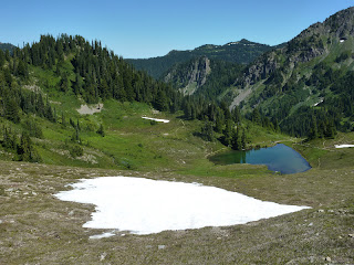
At sunset I headed off for a little spot at the start of the Catwalk where the best view in perhaps all of Olympic Park, but certainly in Sol Duc can be had. I had discovered it on the way that morning and the return was quick and exciting, with my second bear sighting. I again rap-rap-rapped and this bear looked at me calmly and ignored me. I told an older couple camping at my sunset spot that a bear was nearby to them and probably moving their way. The result was pretty much an eye roll from two people who think young people are idiots. When I was leaving the bear had made it to pretty much right outside their tent, but I did not alert them again. I figure they are pros at this, or they can get mauled and learn to take the advice of well-meaning people next time and be on the alert. Whatever. The bear again showed no concern for me. To find this lovely vantage point to watch a sunset, walk East along the High Divide past Heart Lake. Just about where it turns into "The Catwalk" (there is no sign for this) a sign will say "campsite". Take the very short trail to the campsite or just below the copse of trees to these hills. It is 1/4 mile or so from Heart Lake and may be considered part of that campground, so that with a Heart Lake permit, you could camp here. A small pond will be there some of the year, and snow will be there the rest. This pond is where I found the bear for the last time that night, and is just over a small 15 foot hill from the campsite. So take care in going for water, as a bear could possibly be just over the other side and would freak if you clambored over. Another campsite is on the High Divide Trail just over Heart Lake where the descent starts. You are most likely to share your bed with bears there. It felt like a bear highway to me, or the natural point where bears would climb up to the High Divide Trail to check things out. A group camping the night before I was there reported that a bear just walked right into the midst of their tents and plopped down like one of the guys. There is even grungier water in an even smaller pond to be had there.


Back at Heart Lake I spread news of my bear which made several jealous. I began to suspect this new bear was the same black bear I'd seen earlier as it was also quite large, and had scatted right at a fork in the trail where I had left the main trail earlier to descend to Heart Lake. My vanity told me the scared bear might have stoked his internal fires to follow me for 5 miles and make a show of his territory to let me know not to come back, since I'd spooked him in his male-hood. Unlikely, actually, as that's a lot of territory for one bear to try or want to hold in such lush bear country, but not impossible...I figure that all bears look alike to people though, and at first, I thought them very different. One lake per bear zone is probably how it would have to go because the bears would fight for as much just as people will stake a homestead of fair size and think it their right in the world. Heart Lake has a goat problem, and in the night, they danced about and ran around licking urine and searching for salt, screaming like demons and alerting one another with snorts and grunts and scratches of hooves to noises and concerns. I do not believe they ever knew I was camped among them, low to the ground in a dark green bivy sac, with a perimeter of trees around me, and that is how I intended it.
I moved off very early in morning to catch the sunrise and got the very brief and decent only one there was. The day hazed over quickly though I did not mind, as I had had better views of Mt Olympus for sunset and from my "Secret Garden" adventure the day before. The High Divide is comparable for those not physically up to "Secret Garden" but is just a pedestrian walkway. The views are better and more natural if you approach from the West towards Heart Lake (from Deer Lake). The rest of Sol Duc was let-down. Bogachiel Peak was a brief diversion only worth it for the padding of my career mountain climb/hike numbers. The 7 lake Basin was still much frozen and ugly anyway. I did not descend to it, tarry, or take any pictures. Lunch Lake was small though I did stop to eat a little there and take some water. Deer Lake is crowded, cluttered with signs and signs of man, and large, but typical of mountain lakes. I did not stay long. The trail from there to the waterfall is brutal, a thuggish affair of ankle-rolling crud rocks, tedious trees, steepness, and letdown. I'd say the ground underfoot is so vicious that I'd not have done the loop had I known. I'd have gone back down the Sol Duc River. Now I do know and I warn you. Appleton Pass, Sol Duc River, the famous falls, and "The Secret Garden" are all worth doing. Haig's Lake is ugly late in year but would provide ample serenity, privacy, and opportunity to see wildlife if camping there. It is just outside of the quota zone and thus, can be legally camped at, with a permit. The rest of Sol Duc I did not like. Well that was a long story and probably too long, but if you are still here, I hoped you enjoy it, and I hope you can go try some of this area someday.


Above: Heart Lake beating in the chest of the sunrise. Below flowers in the wind as haze takes over Mt Olympus and bleaches it from view.


The Wilderness Info Center is extremely inconvenient in Port Angeles, WA, as Olympic National Park is sprawling and vast, but it is the only place to get permits for the quota areas so I drove 30 miles out of my way, and then 30 miles back to talk with them, and for the advice and trip planning aid I got, it was well worth the trip. I had a bad trip planned and my ranger friend provided me with a much more pleasant and rewarding experience thanks to their knowledge of the area. That is what rangers are for in my mind. Although more typically rangers exist to amuse tourists, and ensure their return with money. That can mean shooing bears, playing "junior ranger" with kids, and checking bathrooms for toilet paper and cleanliness. But helping actual real hikers and adventurers to enjoy wild land is probably a nice change of pace for them, maybe.
My trip began around noon at the Sol Duc trailhead. There is only one, from a huge parking area. 1 mile of easy and pretty trail gets you to a popular three-headed hydra of a waterfall, pretty and lush, and the views only partly marred by overlooks and structure. I saw a small rainbow while there in the morning mist, and got some other impressive and even stunning light effects between some trees, like this below:


 From the falls, I took the Sol Duc River trail about 4 miles slightly uphill over mostly easy soft, springy lush ground through very pretty forest with only occassional rocks. A few falls along the way are hard to view but impressive from afar. The trail will then fork, to the right is the common route along the High Divide Loop. Appleton Pass and campground await the traveller to the left, and so does a steep, surprisingly direct trail with few switchbacks (praise God!) and direct, hard lines up the sides of some sun-struck, hot slopes through much less pretty forest. A few mangy views from meadows and openings in the trees are best neglected. A few mudpots pass for ponds and are best skipped past quickly. A pretty creek crossing is mossy and sparkling like a trickle of diamonds at one point. Appleton Pass is 2.5 miles from the split, making for a 7.5 mile day from the TH, not bad, though it took most parties with a pack most of the day, as I passed a group of eight and the campground was empty from 3 pm when I got there until around dusk, when I was passing back down a ways to scramble up some ridge rocks for sunset photos.


Appleton Pass itself is dreary and uninspiring, though to the left moderately pretty Mt Appleton sits. The campground sprawls for 1/2 a mile towards and then past Oyster Lake, the only water source, to the top of an unnamed tableaux of a mountain that plateaus rather than peaks. The best views are from the final campsite, basically atop this mountain near a stunning field of wildflowers, but the walk for water will be long. A couple small sites are available at the lake and are perfect for the bivouac man, like myself. I tucked under some trees and gave myself a 2 sided shelter of thick brush, hid in the shade all afternoon, and tried to ignore the bugs who tried to ignore my bug spray. This made me all but invisible and it paid off when a family of three deer walked right up and I nearly got the best baby deer picture of all time, but my target turned from me and dropped a hoof he was scratching himself with so I had to settle for this:


Later in the evening a large elk came by also unaware of me. In the morning it was two adolescent male deer, brothers or best friends, who came trotting up for water before freezing when they found me at their favorite watering hole filtering for myself. The lake is central to the pretty flower field or the ridge near Mt Appleton that provides the best expansive sunset view. Sunrise I think would be a sorry affair with glare spots right in your lens or a blinding light stopping you from seeing much. A 10 minute scramble up the ridge along boot tracks will get you as good a view as another hour of climbing will. I went as far as willing with the hope of summiting Mt Appleton before realizing the brush was getting thick, the going slow, and the effort too much with diminishing returns. So I headed back down, took a few pictures, and missed the true alpine glow of glowing red peaks by 5 minutes. I gave up on the sunset too early and kicked myself, but still had some decent pictures.


There are also flowers near the lake:

The charming pic above is centered around scenic but rugged to approach Mt Appleton.
Appleton Pass was much prettier than I hoped, though Oyster Lake was too small and partly frozen to swim in. But the hike in was not so hot as I expected and a little shade made me feel quite refreshed. I slept solidly, though deer were about me, and I was a little anxious about bears, because if I were a bear, I would live there, and I was already right on a deer highway. The rangers told me this night was the peak of a meteor shower, but when I got up a few times to relieve myself against some trees, I saw nothing but the usual few shooting stars, though there were a jaw-dropping number of stars above me, more than usual when I scan the wilderness heights above me. Or they just impressed me more this night. Temperature was wonderful around the middle 40s.
I got up early as I had a long day potentially, if I wanted to climb Mt Carrie. I felt good about taking this pseudo trail, not on the maps, now, as I had scouted it the evening before, but I did not want to miss the peak of the sunrise for the wildflower meadow. Got a later start than I wanted filtering water. But couldn't trust any of the water sources on the map this late in the summer. Made the meadows by a little before 6 which was just right. Maybe 5 minutes late, but still awesome:


And then when I was finished shooting the mountains I was heading through and over to reach a further set of peaks, I noticed a bear munching flowers a few hundred feet from the trail. This was near a campsite of a solo hiker so I tapped on his tent wall and pardoned myself to wake him, but "just to let you know, if you hear any noises, its a fully grown 350 lb blackbear just outside your camp eating flowers" I said. He was up in a hurry, but did not see the bear. After taking some pictures I did not want to spook my fluffy friend so I tapped 3 steady raps on a rock with my ice axe rap-rap-rap. The bear looked over at me with a quick head turn, did a double take freeze frame look of shock, and then loped at full gallop across the meadow away into the thickets. This brings me to a good point: do not summit the forested peak that Appleton Camp sits on. Count it as a mountain if you go up the flower meadow or take the trail past Oyster Lake as you are only a hundred feet or so from the high point and would have to pass through heavy ideal bear habitat to make the summit. I was smarter or lazier than usual and saved myself a mauling the night before, perhaps, by not going up there. Do the same, I suggest. My friend came out and thanked me for alerting him. I was glad he was not crabby and sorry I had chased off his bear. I never thought a grown bear would look at me from afar and run FROM me. That is not what the rangers or literature prepare you for. They make it sound like a bear will get spooked and come at you. I am pretty gruesome to behold though in the morning, I guess.
Headed along my trail, which crossed snowfields and disappeared quickly and several times. Big piles of bear scat abounded, and I was glad to know already where the bear was. A second was unlikely as they are solitary and territorial. I knew where the trail should go and where it wound up from the night before so trusted instinct and caught it again. The trail is evident usually and intuitive enough with perhaps some foraging and contemplation time. The trail is pretty all the way and cuts along the side of a peak in a small but pretty range of lush mountains. I named the peak where the trail hits a small pass, "Wildflower Mountain" and summited it. This was easy, though it is challenging not to crush flowers or bushes beneath your boots. Please take care if you go up to "Wildflower Mountain's" summit. There is no trail and few will have been up there before. The view is pretty and I think worth the diversion of a half hour. From there the trail traverses several other peaks, faint in places, but intuitive in that the trail cannot go anyplace else logically unless other mountaineers wanted to go down a steep 1,000 hill for no reason just to go up another in a half mile. So take your time looking around when in doubt and if there are several in your party, things are easy. Go in every direction and call when evidence of trail is found again. Alone, its harder. The trail stays good and easy, though in earlier summer, you will have more snow and ice to deal with. I fell on a bad ice field, though not badly. Just got my pants and hands wet. Eventually, after 3 miles or so, things get sketchier, fainter, steeper, rockier, bushwhackier, nastier, pokier, trippier, fallier, and generally unpleasant. The way stops being fun. I fell more in a mile than I have in my whole life I think, cut my hand, rolled ankles, cursed, muttered, got worn down, and then found myself in a rock scree field with no trail at all in sight and nothing obvious about where to go. I was in hot sun but stopped for water and to scan the map. The most sensible plan to me was to go to this lake near me which I thought must be on the map as Haig's Lake, anticipating that lakes always have trails to and from them worn down by hopeful fishermen with favorite secret spots. This logic worked out perfectly for me as from the lake to the Catwalk, which is on the map, and is a spur trail extension from the official High Divide trail, I never was in doubt again. I was in sun, in brush, on steep traverse slopes, hating the sudden scorched area, the ugly lake, the falling, and everything generally. I made the Catwalk and took a break.

Below is the view back along the first half of "The Secret Garden" trail. Taken from "Wildflower Mountain" summit (my name) looking back at Mt Appleton and the pass it shares with "Appleton Jr", or "Camp Peak"- take your choice of what to call the other mountain where the bear lives and the campsite actually sits.


My original hope was to go from here to Mount Carrie, but I was sick of off-roading, and the Catwalk was dry, hot, gravelly, and ugly, and looking at the map I was probably 5 miles to Mount Carrie still as the shortcut trail had not been able to take me closer to Carrie (without an extra 1000 feet drop and feeding me into some more serious cliffs and slopes than on the "official" route). I gave up the idea as I had no inkling of if or when I would find water, my feet were hot and tired, and the mountain looked out of condition. I'd say the Baileys are impressive and satisfying climbs in spring and summer, but by late summer, with most of the snow gone, I think its more of a hot groan than elation. Also, I cannot imagine the views are much different or better than they were along "The Secret Garden" trail, though you would be higher up. We're talking marginal differences in beauty here though. Pick your battles. This did give me a long wait day at Heart's Lake though, as I did not want to press through and beat it out that afternoon, with hot sun all around me obscuring views and crowds to contend with on a popular trail. I found a shaded campsight easy to "defend" and took naps, dips in the lake, and ate all day listening to short stories on my electronic player. It was the kind of ease and relaxation the wild so often does not entail for me as I move constantly. And I enjoyed it, despite the efforts of many bugs. Below is my artsy framing of Heart Lake with a Heart snowfield just above it. Is this art or luck? This is the sort of thing that separates a "photographer" from a guy with a camera, I suppose, though I still don't feel like taking pictures is much. Its not painting, that's for sure. Digital is too easy.

At sunset I headed off for a little spot at the start of the Catwalk where the best view in perhaps all of Olympic Park, but certainly in Sol Duc can be had. I had discovered it on the way that morning and the return was quick and exciting, with my second bear sighting. I again rap-rap-rapped and this bear looked at me calmly and ignored me. I told an older couple camping at my sunset spot that a bear was nearby to them and probably moving their way. The result was pretty much an eye roll from two people who think young people are idiots. When I was leaving the bear had made it to pretty much right outside their tent, but I did not alert them again. I figure they are pros at this, or they can get mauled and learn to take the advice of well-meaning people next time and be on the alert. Whatever. The bear again showed no concern for me. To find this lovely vantage point to watch a sunset, walk East along the High Divide past Heart Lake. Just about where it turns into "The Catwalk" (there is no sign for this) a sign will say "campsite". Take the very short trail to the campsite or just below the copse of trees to these hills. It is 1/4 mile or so from Heart Lake and may be considered part of that campground, so that with a Heart Lake permit, you could camp here. A small pond will be there some of the year, and snow will be there the rest. This pond is where I found the bear for the last time that night, and is just over a small 15 foot hill from the campsite. So take care in going for water, as a bear could possibly be just over the other side and would freak if you clambored over. Another campsite is on the High Divide Trail just over Heart Lake where the descent starts. You are most likely to share your bed with bears there. It felt like a bear highway to me, or the natural point where bears would climb up to the High Divide Trail to check things out. A group camping the night before I was there reported that a bear just walked right into the midst of their tents and plopped down like one of the guys. There is even grungier water in an even smaller pond to be had there.


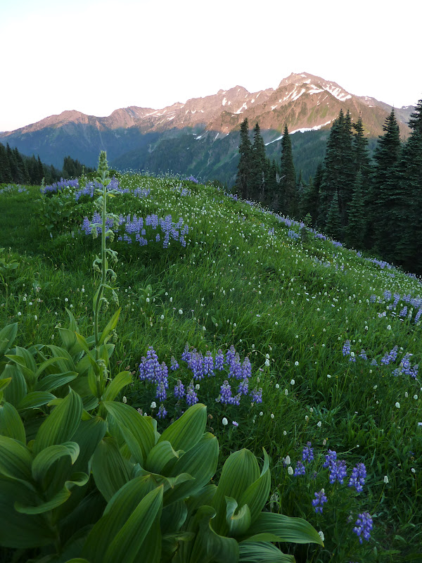


Back at Heart Lake I spread news of my bear which made several jealous. I began to suspect this new bear was the same black bear I'd seen earlier as it was also quite large, and had scatted right at a fork in the trail where I had left the main trail earlier to descend to Heart Lake. My vanity told me the scared bear might have stoked his internal fires to follow me for 5 miles and make a show of his territory to let me know not to come back, since I'd spooked him in his male-hood. Unlikely, actually, as that's a lot of territory for one bear to try or want to hold in such lush bear country, but not impossible...I figure that all bears look alike to people though, and at first, I thought them very different. One lake per bear zone is probably how it would have to go because the bears would fight for as much just as people will stake a homestead of fair size and think it their right in the world. Heart Lake has a goat problem, and in the night, they danced about and ran around licking urine and searching for salt, screaming like demons and alerting one another with snorts and grunts and scratches of hooves to noises and concerns. I do not believe they ever knew I was camped among them, low to the ground in a dark green bivy sac, with a perimeter of trees around me, and that is how I intended it.
I moved off very early in morning to catch the sunrise and got the very brief and decent only one there was. The day hazed over quickly though I did not mind, as I had had better views of Mt Olympus for sunset and from my "Secret Garden" adventure the day before. The High Divide is comparable for those not physically up to "Secret Garden" but is just a pedestrian walkway. The views are better and more natural if you approach from the West towards Heart Lake (from Deer Lake). The rest of Sol Duc was let-down. Bogachiel Peak was a brief diversion only worth it for the padding of my career mountain climb/hike numbers. The 7 lake Basin was still much frozen and ugly anyway. I did not descend to it, tarry, or take any pictures. Lunch Lake was small though I did stop to eat a little there and take some water. Deer Lake is crowded, cluttered with signs and signs of man, and large, but typical of mountain lakes. I did not stay long. The trail from there to the waterfall is brutal, a thuggish affair of ankle-rolling crud rocks, tedious trees, steepness, and letdown. I'd say the ground underfoot is so vicious that I'd not have done the loop had I known. I'd have gone back down the Sol Duc River. Now I do know and I warn you. Appleton Pass, Sol Duc River, the famous falls, and "The Secret Garden" are all worth doing. Haig's Lake is ugly late in year but would provide ample serenity, privacy, and opportunity to see wildlife if camping there. It is just outside of the quota zone and thus, can be legally camped at, with a permit. The rest of Sol Duc I did not like. Well that was a long story and probably too long, but if you are still here, I hoped you enjoy it, and I hope you can go try some of this area someday.


Above: Heart Lake beating in the chest of the sunrise. Below flowers in the wind as haze takes over Mt Olympus and bleaches it from view.


Well, let's end with that one above. Its stellar. Orange paintbrush was one of the only rare flowers on this hike. And I took this one for the incredibly vibrant red paintbrush cluster in the upper left. I've never seen brighter ones, so they must fade every day after blooming. The peak behind is nothing of merit or note. Not named on maps.
Total trip was 2.5 days and 2 nights, with about 30 miles of trail and pseudo trails, all told.
Subscribe to:
Posts (Atom)