Showing posts with label route. Show all posts

Saturday, August 25, 2012

The Secret Garden

A pseudo trail provides high thrills in Olympic National Park's Sol Duc section.  As always prints are available if you'd like any, and I clean up the colors on actual photos where needed.

The Sol Duc area of Olympic National Park is very popular, so popular that there are quotas in place for backcountry camping which make it difficult to visit and enjoy the area.  I found a good compromise to this by camping just outside the quota zone at Appleton Pass, a high elevation campsite 2.6 miles out of the way of the famous loop that takes in the High Divide Trail, often called "The High Divide Loop."  My plan was to backtrack downhill 2.6 miles the next morning after camping and beat it out all in one day for the rest, but a better plan was suggested by a friendly and very helpful ranger at the Wilderness Info Center.  He said there was a trail from Appleton Pass to the Catwalk which meant I need not backtrack.  It was a footpath, but would be faint, disappear some, though the route would be intuitive.  Also he found me a Sunday night slot at Heart Lake, which was great on short notice, and surprising.  He advised me to use it and not try to make it all the way out in one day.  Mileage-wise, it would have been okay, but I was glad for this advice as most of the trail is in the sun, especially the High Divide 2 mile section, and anytime after morning is brutal to be up there.  People do it, but I do not personally know how they can enjoy it.  But that is all in due time.

The Wilderness Info Center is extremely inconvenient in Port Angeles, WA, as Olympic National Park is sprawling and vast, but it is the only place to get permits for the quota areas so I drove 30 miles out of my way, and then 30 miles back to talk with them, and for the advice and trip planning aid I got, it was well worth the trip.  I had a bad trip planned and my ranger friend provided me with a much more pleasant and rewarding experience thanks to their knowledge of the area.  That is what rangers are for in my mind.  Although more typically rangers exist to amuse tourists, and ensure their return with money.  That can mean shooing bears, playing "junior ranger" with kids, and checking bathrooms for toilet paper and cleanliness.  But helping actual real hikers and adventurers to enjoy wild land is probably a nice change of pace for them, maybe.

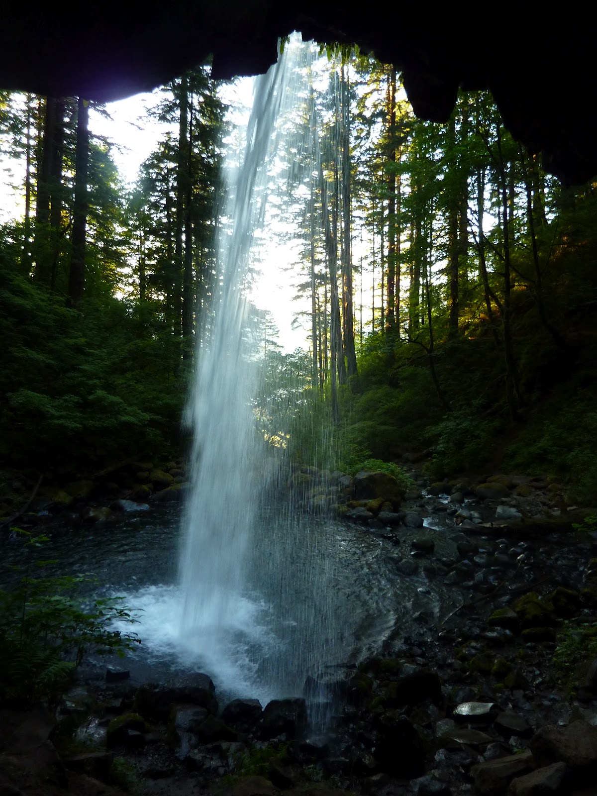
My trip began around noon at the Sol Duc trailhead.  There is only one, from a huge parking area.  1 mile of easy and pretty trail gets you to a popular three-headed hydra of a waterfall, pretty and lush, and the views only partly marred by overlooks and structure.  I saw a small rainbow while there in the morning mist, and got some other impressive and even stunning light effects between some trees, like this below:

From the falls, I took the Sol Duc River trail about 4 miles slightly uphill over mostly easy soft, springy lush ground through very pretty forest with only occassional rocks.  A few falls along the way are hard to view but impressive from afar.  The trail will then fork, to the right is the common route along the High Divide Loop.  Appleton Pass and campground await the traveller to the left, and so does a steep, surprisingly direct trail with few switchbacks (praise God!) and direct, hard lines up the sides of some sun-struck, hot slopes through much less pretty forest.  A few mangy views from meadows and openings in the trees are best neglected.  A few mudpots pass for ponds and are best skipped past quickly.  A pretty creek crossing is mossy and sparkling like a trickle of diamonds at one point.  Appleton Pass is 2.5 miles from the split, making for a 7.5 mile day from the TH, not bad, though it took most parties with a pack most of the day, as I passed a group of eight and the campground was empty from 3 pm when I got there until around dusk, when I was passing back down a ways to scramble up some ridge rocks for sunset photos. 


Appleton Pass itself is dreary and uninspiring, though to the left moderately pretty Mt Appleton sits.  The campground sprawls for 1/2 a mile towards and then past Oyster Lake, the only water source, to the top of an unnamed tableaux of a mountain that plateaus rather than peaks.  The best views are from the final campsite, basically atop this mountain near a stunning field of wildflowers, but the walk for water will be long.  A couple small sites are available at the lake and are perfect for the bivouac man, like myself.  I tucked under some trees and gave myself a 2 sided shelter of thick brush, hid in the shade all afternoon, and tried to ignore the bugs who tried to ignore my bug spray.  This made me all but invisible and it paid off when a family of three deer walked right up and I nearly got the best baby deer picture of all time, but my target turned from me and dropped a hoof he was scratching himself with so I had to settle for this:


Later in the evening a large elk came by also unaware of me.  In the morning it was two adolescent male deer, brothers or best friends, who came trotting up for water before freezing when they found me at their favorite watering hole filtering for myself.  The lake is central to the pretty flower field or the ridge near Mt Appleton that provides the best expansive sunset view.  Sunrise I think would be a sorry affair with glare spots right in your lens or a blinding light stopping you from seeing much.  A 10 minute scramble up the ridge along boot tracks will get you as good a view as another hour of climbing will.  I went as far as willing with the hope of summiting Mt Appleton before realizing the brush was getting thick, the going slow, and the effort too much with diminishing returns.  So I headed back down, took a few pictures, and missed the true alpine glow of glowing red peaks by 5 minutes.  I gave up on the sunset too early and kicked myself, but still had some decent pictures.


There is a chain of peaks in front and a chain of peaks behind, much rockier, and more sombre-looking, in the left corner above.  That second distant set of peaks is The Baileys, often climbed, though not so easy to access.  Though easy by Olympic National Park mountain standards, I suppose.  The highest is Mt Carrie and was my hope for the next day.  On the right corner background you see the real and true Mt Olympus the park is named after, accessible by a 17 mile river trail through a rainforest.  The lots of glacier travel, best early in summer.


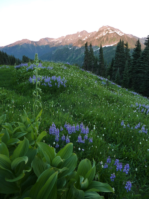
There are also flowers near the lake:
The charming pic above is centered around scenic but rugged to approach Mt Appleton.


Appleton Pass was much prettier than I hoped, though Oyster Lake was too small and partly frozen to swim in.  But the hike in was not so hot as I expected and a little shade made me feel quite refreshed.  I slept solidly, though deer were about me, and I was a little anxious about bears, because if I were a bear, I would live there, and I was already right on a deer highway.  The rangers told me this night was the peak of a meteor shower, but when I got up a few times to relieve myself against some trees, I saw nothing but the usual few shooting stars, though there were a jaw-dropping number of stars above me, more than usual when I scan the wilderness heights above me.  Or they just impressed me more this night.  Temperature was wonderful around the middle 40s. 


I got up early as I had a long day potentially, if I wanted to climb Mt Carrie.  I felt good about taking this pseudo trail, not on the maps, now, as I had scouted it the evening before, but I did not want to miss the peak of the sunrise for the wildflower meadow.  Got a later start than I wanted filtering water.  But couldn't trust any of the water sources on the map this late in the summer.  Made the meadows by a little before 6 which was just right.  Maybe 5 minutes late, but still awesome:


And then when I was finished shooting the mountains I was heading through and over to reach a further set of peaks, I noticed a bear munching flowers a few hundred feet from the trail.  This was near a campsite of a solo hiker so I tapped on his tent wall and pardoned myself to wake him, but "just to let you know, if you hear any noises, its a fully grown 350 lb blackbear just outside your camp eating flowers" I said.  He was up in a hurry, but did not see the bear.  After taking some pictures I did not want to spook my fluffy friend so I tapped 3 steady raps on a rock with my ice axe rap-rap-rap.  The bear looked over at me with a quick head turn, did a double take freeze frame look of shock, and then loped at full gallop across the meadow away into the thickets.  This brings me to a good point: do not summit the forested peak that Appleton Camp sits on.  Count it as a mountain if you go up the flower meadow or take the trail past Oyster Lake as you are only a hundred feet or so from the high point and would have to pass through heavy ideal bear habitat to make the summit.  I was smarter or lazier than usual and saved myself a mauling the night before, perhaps, by not going up there.  Do the same, I suggest.  My friend came out and thanked me for alerting him.  I was glad he was not crabby and sorry I had chased off his bear.  I never thought a grown bear would look at me from afar and run FROM me.  That is not what the rangers or literature prepare you for.  They make it sound like a bear will get spooked and come at you.  I am pretty gruesome to behold though in the morning, I guess.


Headed along my trail, which crossed snowfields and disappeared quickly and several times.  Big piles of bear scat abounded, and I was glad to know already where the bear was.  A second was unlikely as they are solitary and territorial.  I knew where the trail should go and where it wound up from the night before so trusted instinct and caught it again.  The trail is evident usually and intuitive enough with perhaps some foraging and contemplation time.  The trail is pretty all the way and cuts along the side of a peak in a small but pretty range of lush mountains.  I named the peak where the trail hits a small pass, "Wildflower Mountain" and summited it.  This was easy, though it is challenging not to crush flowers or bushes beneath your boots.  Please take care if you go up to "Wildflower Mountain's" summit.  There is no trail and few will have been up there before.  The view is pretty and I think worth the diversion of a half hour.  From there the trail traverses several other peaks, faint in places, but intuitive in that the trail cannot go anyplace else logically unless other mountaineers wanted to go down a steep 1,000 hill for no reason just to go up another in a half mile.  So take your time looking around when in doubt and if there are several in your party, things are easy.  Go in every direction and call when evidence of trail is found again.  Alone, its harder.  The trail stays good and easy, though in earlier summer, you will have more snow and ice to deal with.  I fell on a bad ice field, though not badly.  Just got my pants and hands wet.  Eventually, after 3 miles or so, things get sketchier, fainter, steeper, rockier, bushwhackier, nastier, pokier, trippier, fallier, and generally unpleasant.  The way stops being fun.  I fell more in a mile than I have in my whole life I think, cut my hand, rolled ankles, cursed, muttered, got worn down, and then found myself in a rock scree field with no trail at all in sight and nothing obvious about where to go.  I was in hot sun but stopped for water and to scan the map.  The most sensible plan to me was to go to this lake near me which I thought must be on the map as Haig's Lake, anticipating that lakes always have trails to and from them worn down by hopeful fishermen with favorite secret spots.  This logic worked out perfectly for me as from the lake to the Catwalk, which is on the map, and is a spur trail extension from the official High Divide trail, I never was in doubt again.  I was in sun, in brush, on steep traverse slopes, hating the sudden scorched area, the ugly lake, the falling, and everything generally.  I made the Catwalk and took a break.


Below is the view back along the first half of "The Secret Garden" trail.  Taken from "Wildflower Mountain" summit (my name) looking back at Mt Appleton and the pass it shares with "Appleton Jr", or "Camp Peak"- take your choice of what to call the other mountain where the bear lives and the campsite actually sits.


 I decided this trail should be named "The Secret Garden Trail" due to all the amazing flowers and pretty peaks you pass through, and that is a good name too since it is not on the map, is not official, maintained, or easy, and is only mentioned by the rangers if you specifically ask, or if they think you are up to it and deserve it.  This trail is a good trial and gatekeeper for itself, in that, if you can't find your way onto it, you shouldn't be on it, because it is a demanding few hours, about 5 miles total, with 1 mile of that a total bushwhack through bad gravel and turf and over trees and with a good probability of tripping.  You'll need to be a packrobat to be sure: one capable of gymnastics moves with weight on your shoulders.  I had my usual 20 lb pack on, but anyone with a tent would really struggle, not so much with the weight of a full pack, but with the size of it.  I had to duck and dodge and dive and dip under and over and around logs and go to my knees a couple times to slip under fallen trees, and with a bigger bag, I'd have had to take it off for each move and drag it after me and then strap it back on.  I'd have been a grouch by the end, more so.  But for the traveller who can move lightly, or even better, a day tripper camping at Heart Lake or Appleton Pass, then this is a great trail, on with special views of Mt Olympus and its 6 peaks, the Bailey Mountains and the lush smaller peaks you have to traverse through.  My best description is simple and better than what I was given and is this: The Secret Garden Trail runs from Oyster Lake to Haig's Lake, through a small range of mountains, mostly traversing them, and connects at Haig's Lake to a lesser used branch of "The Catwalk".  Any route can be taken but if you don't feel like needlessly climbing up and down several steep hills, head East first to a pass between 2 close neighbor peaks easily spotted on the map, and then go Southwest in approximately a straight line to Haig's Lake, traversing the mountains as practicable.  If you can read a map at all, that will explain everything you need.  Try and get lost now.  If you need more than that, its not the trail for you, take the High Divide Trail and take comfort knowing the views are similar. 

 My original hope was to go from here to Mount Carrie, but I was sick of off-roading, and the Catwalk was dry, hot, gravelly, and ugly, and looking at the map I was probably 5 miles to Mount Carrie still as the shortcut trail had not been able to take me closer to Carrie (without an extra 1000 feet drop and feeding me into some more serious cliffs and slopes than on the "official" route).  I gave up the idea as I had no inkling of if or when I would find water, my feet were hot and tired, and the mountain looked out of condition.  I'd say the Baileys are impressive and satisfying climbs in spring and summer, but by late summer, with most of the snow gone, I think its more of a hot groan than elation.  Also, I cannot imagine the views are much different or better than they were along "The Secret Garden" trail, though you would be higher up.  We're talking marginal differences in beauty here though.  Pick your battles.  This did give me a long wait day at Heart's Lake though, as I did not want to press through and beat it out that afternoon, with hot sun all around me obscuring views and crowds to contend with on a popular trail.  I found a shaded campsight easy to "defend" and took naps, dips in the lake, and ate all day listening to short stories on my electronic player.  It was the kind of ease and relaxation the wild so often does not entail for me as I move constantly.  And I enjoyed it, despite the efforts of many bugs.  Below is my artsy framing of Heart Lake with a Heart snowfield just above it.  Is this art or luck?  This is the sort of thing that separates a "photographer" from a guy with a camera, I suppose, though I still don't feel like taking pictures is much.  Its not painting, that's for sure.  Digital is too easy.


At sunset I headed off for a little spot at the start of the Catwalk where the best view in perhaps all of Olympic Park, but certainly in Sol Duc can be had.  I had discovered it on the way that morning and the return was quick and exciting, with my second bear sighting.  I again rap-rap-rapped and this bear looked at me calmly and ignored me.  I told an older couple camping at my sunset spot that a bear was nearby to them and probably moving their way.  The result was pretty much an eye roll from two people who think young people are idiots.  When I was leaving the bear had made it to pretty much right outside their tent, but I did not alert them again.  I figure they are pros at this, or they can get mauled and learn to take the advice of well-meaning people next time and be on the alert.  Whatever.  The bear again showed no concern for me.  To find this lovely vantage point to watch a sunset, walk East along the High Divide past Heart Lake.  Just about where it turns into "The Catwalk" (there is no sign for this) a sign will say "campsite".  Take the very short trail to the campsite or just below the copse of trees to these hills.  It is 1/4 mile or so from Heart Lake and may be considered part of that campground, so that with a Heart Lake permit, you could camp here.  A small pond will be there some of the year, and snow will be there the rest.  This pond is where I found the bear for the last time that night, and is just over a small 15 foot hill from the campsite.  So take care in going for water, as a bear could possibly be just over the other side and would freak if you clambored over.  Another campsite is on the High Divide Trail just over Heart Lake where the descent starts.  You are most likely to share your bed with bears there.  It felt like a bear highway to me, or the natural point where bears would climb up to the High Divide Trail to check things out.  A group camping the night before I was there reported that a bear just walked right into the midst of their tents and plopped down like one of the guys.  There is even grungier water in an even smaller pond to be had there.


Back at Heart Lake I spread news of my bear which made several jealous.  I began to suspect this new bear was the same black bear I'd seen earlier as it was also quite large, and had scatted right at a fork in the trail where I had left the main trail earlier to descend to Heart Lake.  My vanity told me the scared bear might have stoked his internal fires to follow me for 5 miles and make a show of his territory to let me know not to come back, since I'd spooked him in his male-hood.  Unlikely, actually, as that's a lot of territory for one bear to try or want to hold in such lush bear country, but not impossible...I figure that all bears look alike to people though, and at first, I thought them very different.  One lake per bear zone is probably how it would have to go because the bears would fight for as much just as people will stake a homestead of fair size and think it their right in the world.  Heart Lake has a goat problem, and in the night, they danced about and ran around licking urine and searching for salt, screaming like demons and alerting one another with snorts and grunts and scratches of hooves to noises and concerns.  I do not believe they ever knew I was camped among them, low to the ground in a dark green bivy sac, with a perimeter of trees around me, and that is how I intended it. 


I moved off very early in morning to catch the sunrise and got the very brief and decent only one there was.  The day hazed over quickly though I did not mind, as I had had better views of Mt Olympus for sunset and from my "Secret Garden" adventure the day before.  The High Divide is comparable for those not physically up to "Secret Garden" but is just a pedestrian walkway.  The views are better and more natural if you approach from the West towards Heart Lake (from Deer Lake).  The rest of Sol Duc was let-down.  Bogachiel Peak was a brief diversion only worth it for the padding of my career mountain climb/hike numbers.  The 7 lake Basin was still much frozen and ugly anyway.  I did not descend to it, tarry, or take any pictures.  Lunch Lake was small though I did stop to eat a little there and take some water.  Deer Lake is crowded, cluttered with signs and signs of man, and large, but typical of mountain lakes.  I did not stay long.  The trail from there to the waterfall is brutal, a thuggish affair of ankle-rolling crud rocks, tedious trees, steepness, and letdown.  I'd say the ground underfoot is so vicious that I'd not have done the loop had I known.  I'd have gone back down the Sol Duc River.  Now I do know and I warn you.  Appleton Pass, Sol Duc River, the famous falls, and "The Secret Garden" are all worth doing.  Haig's Lake is ugly late in year but would provide ample serenity, privacy, and opportunity to see wildlife if camping there.  It is just outside of the quota zone and thus, can be legally camped at, with a permit.  The rest of Sol Duc I did not like.  Well that was a long story and probably too long, but if you are still here, I hoped you enjoy it, and I hope you can go try some of this area someday. 


Above: Heart Lake beating in the chest of the sunrise.  Below flowers in the wind as haze takes over Mt Olympus and bleaches it from view.


Well, let's end with that one above.  Its stellar.  Orange paintbrush was one of the only rare flowers on this hike.  And I took this one for the incredibly vibrant red paintbrush cluster in the upper left.  I've never seen brighter ones, so they must fade every day after blooming.  The peak behind is nothing of merit or note.  Not named on maps.

Total trip was 2.5 days and 2 nights, with about 30 miles of trail and pseudo trails, all told.


Wednesday, August 22, 2012

Mount Rainier National Park and Multnomah Falls area

Having spent a full day at Mt St Helens unplanned, I needed to move quick at Mount Rainier, and I did not have the legs for it.  Prints available for any of these, and others over at my website, for any interested.  Or steal them.  How will I know?  Its sort of a victimless crime.  Unless you believe in Karma, and that the universe, when being formed by it, anticipated the internet.  Mormons seem to believe Jesus does not apply to the insides of cars, I've noticed.  They'll run you over after holding the door open for you coming out of church.

My plan for Mt Rainier was to hit all the different areas of the park: Paradise, the Tatoosh Range, Steven's Creek, several waterfalls, and then Sunrise on the North side.  I had to drive several slow winding hours from Helens which ate up the very early morning.  I made one stop at the Iron Creek Falls, which are beautiful, easy to access, and look like they could be on a tropical island.  Stop if you nearby.  I also include here pictures from the Multnomah area, as I am not going to post for them separately.  These falls I visited on the evening of my first night of travel, after driving 800 miles and 12 hours.  I had too little time and some of the falls did not come out.  Multnomah is the most famous and has a bridge across the view, and is photographed 10,000 times daily.  These falls are Ponytail, Horsetail, and Lower Oneonta.  The Lower Oneonta is waded to through a creek, which I tried the previous May on a cold raining morning, giving it up when I would have had to swim a 10 foot deep section and I could not feel any part of my body.  I was hanging on the walls of the steep gorge to get my feet out of the water periodically.  So the hike was unfinished business for me, and I actually headed to Portland first just to make sure I got this in.  Nothing was going to deny me, even the still-icy water being 4 feet or more deep, which I just plowed right through.  Luckily, my untested waterproof bags held and my Ipod, phone, and wallet suffered no damage, but I got cold.  Most of the pictures did not come out, but its a gorgeous short little adventure, if you can get around a huge log barrier at the start.  Wear water shoes.  I bought a new pair just for this hike earlier in the day, and was lucky to find some in Boise at my one stop of the day other than gas stations.  I had realized I'd left my pair at home in the closet.  Sigh.  Multnomah Falls area and trails remind me very much of Starved Rock State Park, Illinois.  The geography is the same.  Surprisingly so.  The river, the overlooks, the trails, the canyons.  If I mixed pictures, you'd have a hard time knowing which came from where, even having been there.  I suppose these falls do not freeze in winter like the Starved Rock ice falls though. 

Well Paradise area of Rainier is awful.  I hated it.  I was a few weeks early for the peak of the flowers but all the trails are steep, paved, crowded, and you have swarms of "mountaineers" being instructed in ice technique in gear way too good for them as novices that will rot in their closets after and cost hundreds of dollars.  They are clunking around on paved trails in these boots I'd blush to own, though I've gone up more glaciers than the lot of them put together will in a lifetime.  Not much there but a lodge and a gift shop.  I beat it quick, though I did get inspired looking at the Tatoosh Range.  That was my next stop.  I found by the map I'd need to backtrack quite a ways to see waterfalls in the area or Eagle Peak and its trail, and with the day already warm, I gave it up.  I figure enough people take pictures of all the waterfalls in Paradise.  I did take a few pics of the ruined gorgeous falls "Sluiskin Falls".  The Park Service has thoughtfully erected a bridge right across the falls to ruin the shot for you and you won't see it anyway for all the professional photographers hanging out menacingly and staking spots.  But if you push through some trees to a cliff edge you may get a single picture that looks natural and is unique.  As below.  Personally, my advice is skip Paradise entirely.  Its where all the cars and hikers are, so enjoy the rest of the park in solitude.

There are three main trails into the cute small Tatoosh Range of mountains south of Rainier.  Eagle Peak Trail is the longest and accesses the Western end near Longmire.  I missed that trailhead and so started at Pinnacle Peak Trail.  This is a short and sweet trail up to a saddle between steep Pinnacle and another peak named Plummer.  Also accessible is "The Castle".  A popular climb due to a pitch or two of sheer rock.  The trail is short, climbs little, and easy.  Pretty views abound of Rainier, certainly better than at Paradise.  The trail is pleasantly peopled with a few groups on weekdays, it seems, though not many.  Enough to talk to, not to be crowded by.  I saw a mountain goat from afar eating on the side of a sheer wall.  I was impressed.  The trail will be patchy with steep snowbanks melting out until at least August and just assume some will be there all year.  They are hazardous, so take poles or alpine axe.  I had cleats too, but never broke them out, though when on this cliff pictured below, it suddenly struck me that I am perhaps a little over-acclimated to mountain dangers, as I realized one slip would be serious and that I was skipping across like I was playing on beach sand.

From the saddle I walked the surprisingly difficult and far way to Plummer Peak, which is mostly a trail, but gets bushy at the end, actually requiring you climb "through" a tree and then go over a few jagged rocks for your view.  Lady bugs were up there, being swarmy.  I stayed for a bit admiring the swirling clouds out west over a sea of rolling hilly mountains, and Eagle Peak and its ridge, which looked like good solid rock climbing and made me wish I had done the trail.  But at 3.5 miles and much more elevation gain, its a half day or more adventure.  There was a fabulous pyramid down by "Cliff Lake" which sits between Plummer and Eagle.  Made me want to go there.  To the east are great shots of Pinnacle and the Castle, as well as big Unicorn Peak up above Snow Lakes, another popular trail.  No trail goes to Unicorn, but you can bush pretty easily from the Snow Lakes, with the route obvious or so I have read and the map indicates, as well as what I could see with my own eyes.

I worked over to Pinnacle next, which was looking more serious than I'd planned.  A steep scramble.  Turned into a climb for the last few hundred feet which I did not expect until looking at it.  I'd read some basic info that claimed it was a scramble, class 3, but clearly that is the usual bravado of "pro" climbers, the guys who use rope, special shoes, harnesses, and who will never admit that anything was hard, fun, or worthy of their greatness.  Actually, I've found most climbers are real jerks in my time, arrogant, and about the mental and emotional equivalents of pouting 14 year olds.  They will sneer about everything they do in a dismissive way.  And they will tell you something like Pinnacle Peak is just a scramble, class 3.  Its a 5th class climb for at least 2 pitches.  I found slings left there by pro climbers scared to climb down without rope aid, and I am confident that not many people solo climb that peak.  Its easy 5th class.  I'd say 5.5, but the scramble advice is nonsense.  A scramble, 3 class, means occassional use of hands.  I dare anyone to climb the route up Pinnacle with their hands in their pockets as I did on Angel's Landing at Zion.  That is 3 class.  Its a steep walk, with a handhold now and again.  These climbers, they're the best.  Ask them about Mt Everest and they'd say, "oh its hardly a climb.  Don't know why I even bothered.  Now Mars has some big mountains.  15 milers.  And if Kelty Inc ever invents a decent deep sea climbers suit, I could probably find a challenge climbing the Atlantic Deep Sea Ridge from bottom up without a headlamp, blind, like Aqua Man"... well I had fun.  And though its a soup sipping if you're used to mountains and climbing, its not for just anyone.  There is no route, just pick a line and try not to die.  More great views, with swirls of clouds moving in around Rainier.  Headed down to make a run at The Castle, but things were steep enough that I wanted both hands and stowing my axe in the pack was still in my way, getting caught on rocks and making me do some crazy contortions to free it from snags, which put me at risk of that nemesis of many, Gravity.  I dropped the axe down 10 feet and watched with some cursing as it bounced and sang down 500 feet of broken cliffs- all red, and shining in the sun.  My axe is red, by the way, and shines in the sun.

So I spent the next hour going up and down scree and nasty little crumbly cliffs, 4th class mostly (very steep, but not quite vertical) looking for the thing as I was not leaving it.  Eventually found it hundreds of feet above me, dangling hidden from view except from the very spot I was standing.  Couldn't see it as I climbed up, but kept a straight line and found it.  That spent enough time that I gave up on The Castle.  It was hot, bright, and I had other parts of the park to see.  Did take the time to hack away a lot of melting ice ledges on the way down though so hikers the next day would not fall through and get a jolt if not paying attention.  Skipped the Snow Lakes trail as I did not want to climb Unicorn Peak too.  I regretted this later as I met some hikers who told me the lakes were lush with flowers.  But the views from any Tatoosh Peak will be pretty comparable.  In that regard, Plummer is the easiest to reach for most and will do just fine.  If you have a car shuttle, however, the Tatoosh Traverse going from Eagle to Unicorn and down Snow Lakes would be reasonable for a day.  Or start at Snow Lakes Trail and work West to Eagle Peak and trail, as you would start from a higher elevation I think.  The view is always basically of the Tatoosh range you are not on, and of Rainier, which looks pretty much the same from about the entire state of Washington.  I skipped Steven's Creek due to rampant ugliness that was evident from the road, and tried a short touch of the Wonderland Trail which goes 100 miles or so around Rainier.  This section was very pretty and made me want to come back for more someday.  This was around Box Canyon, which is a deep gorge, very pretty, which I got not one single good photograph of.  A pity!  Looked like a greener version of some gorges in Zion National Park, and a taller version of Avalanche Gorge in Glacier (pictured in another post on this blog).  Then I went to Ohanapecosh, on the advice of some fellow travelers probably reading this right now.


Some crazy tree stumps that looked like wheels and the sun lowering on the Wonderland Trail near Box Canyon.  Above, I wondered what people in Paradise were experiencing, with the clouds probably enveloping them completely.  Too late in the day for anyone but an idiot to be on the summit- coming down would be slide city.


Good advice.  A beautiful old-growth forest with easy trails, The Grove of the Patriarchs especially impresses, with massive trees to rival the Sequoiahs or Redwoods of California.  Also there are creek and waterfall opportunities.  I played on some wet cliffs despite signs assuring me I would die if I did so.  I did almost slip, so don't do likewise, unless you have good shoes and are sturdy in them.  Not much more to say than that.  Silver Falls is not so beautiful, but the hike is short.  I drove up next towards Sunrise, but it was too late to reach it.  Tried some pictures of waterfalls along the road.  Most did not come out.  The drive is pretty though I kept few photos.  Of course, there will pro photographers setting up tripods and one actually whistled at me to let me know I was improperly infringing on his staked claim, or something.  He and a friend were setting up taking hundreds of pics of a fall, and I motioned that I was going to pass by and hike to it.  I then started climbing up the thing, all in under 3 minutes, and he began making angry noises.  Apparently it is bad etiquette to stop the 20 clicks per minute digital photo-snapping of a pro at work, when he has an hour of button pressing ahead of him.  I hate photographers.  I don't consider myself one.  I am an adventurer who takes pictures.  This gentleman was also lucky I was in a hurry, there were others around, and I was not quite as feral as I would be within a week's time, or I might have had some words with him too. I did not even deign to sneer at him though.  Wasn't near crabby enough.  Below is a fallen over massive tree you can look up inside the trunk of.  A grown man with kids walked right into it and made the kind of sound 5 year olds do in an ice cream parlor combo toy store for the first time.  It was awesome.  The tree and the guy's super enthusiastic reaction to it.  I may add more pics of some trees but most did not come out. 


I skipped Sunrise when I looked at the road.  Steep, winding, long, and I figured, not worth it.  I can only do so many slow steep roads in a week's time.  So I drove on, and had a time of it looking for someplace to sleep.  Chose a Walmart parking lot some town or other.  Gave me time to find a replacement bandana for one I lost in Glacier.  I bought 2, and promptly lost one within 2 days.  I still have the other, thankfully, though as far as disasters go, losing $2 bandanas and a washcloth (the only things missing when I got home) is pretty tolerable.

 I will probably have a few panoramas out of these pics on the actual website at some point soon.  Have not developed those yet, but got some decent wider views of the Tatoosh range peaks.  What beautiful weather!  I can't promise you'll see Rainier when you go.  Its often masked by clouds.


Mt Rainier, is, as a former resident of Washington told me before going, Mt Rainier.  But you can have fun and do some exploring at other places.  Seemed true to me.  The area is pretty, but a little crowded.  There are some great trails, but don't overdue it.  Include it in a trip to Washington, or hike all the Wonderland Trail.  You could do worse things with your time, but don't try to cover every single trail in the park.  Mt Rainier, from any angle, is Mt Rainier.  If you are climbing the peak, you get the worst of all worlds: super steep, huge, and more prominence (elevation gain) than any peak on the continent, plus hundreds of even thousands of tourists out of their league, paying guides to keep them alive and on the right path.  Doing annoying and dangerous things that ruin your trip.  No thanks, I don't sleep with prostitutes and I don't climb famous or tourist mountains.  That is one sad irony about mountains though: the best mountains go to those who least deserve and appreciate them, and the most dangerous mountains end up getting the most travel, because people like me who like being outdoors take money from rich jerks to help them despoil places they should not be and could not get to otherwise.  Ah life, it takes the thing you love and makes you compromise it.  Well, next stop was the Cascades, a half day's drive away.  But I stumbled upon Fairhaven first, and spent half a day there, recovering my legs and filling my belly with rich soups and other delicacies outlined on my food blog.  I love Fairhaven.