Starting at Bellingham, WA, home of the historic Fairhaven district, which I am in love with, as detailed on www.youngbrokeandclueless.blogpspot.com, my other blog all about food, goes around 60 miles (depending on where you count it as starting) through small agrarian communities first, home to fruit farms, wineries, and the like, and offers pretty farm scenery and then pretty mountain scenery. Hiking opportunities are spaced out and abundant, with mountain peaks and ridgelines, forest hiking along a turquoise river, and of course, the mountain splendor around Artist's Point. I drove in after a good meal and a relaxing afternoon to spend the night in my car, or out on a trail somewhere. I had no real plan in place but intended to scope out Mt Baker as a potential spot and expected to climb Mt Shuksan, a spectacular and fierce mountain I have seen pictures of, much taller than anything else in the area, other than huge Mt Baker, which is more of a routine straight smooth glacier run. Storms were swirling all around, nothing threatening, but all a bit ominous and so several possibilities for that afternoon were off the slate. I stalled for a good hour by taking the trail at Horseshoe Bend along a pretty shining river, glittering like a diamond in the sun as clouds swallowed the tops of all the peaks around me. The trail is easy and flat for a mile, and then starts climbing. Most people quit at the mile, and I advise that too. If you want to go up steep hills, do it someplace where the final payoff will be a mountain with views. The area made me less enthused to go see rainforests, because between Horseshoe Bend and and Ohanapecosh at Mt Rainier, I was pretty sure I'd seen two of the prettiest short forest hikes possible on this earth.


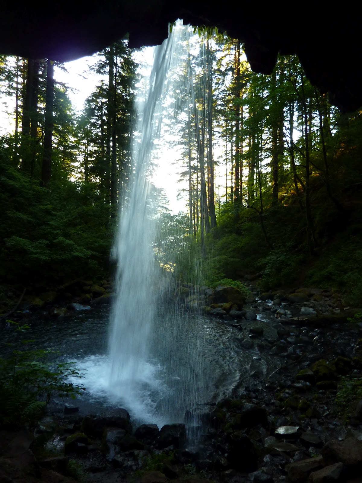
Also nearby to this trail are Nooksack Falls, along an easy and good dirt road. Well worth a short side trip. Many of the following pictures were illegal, because "no trespassing" signs are posted all over this area as the cliffs are slippery and people have a tendency to fall off them. But I figured what is dangerous for other people is not for me and did what I wanted. I thought the cliffs were quite reasonable to walk around, as long as you don't try climbing over the fence to reach them.


Church Mountain, which requires a drive along a steep and rugged dirt road and is not much of a mountain. Skip it if you want my advice. And there is Excelsior Peak and Ridge, another not too impressive mountain that can be accessed from pavement, making it more palatable. The views should be good if you aren't too spoiled from other better views in your life, as I am. I skipped that trail too, in favor of Goat Mountain a few days later, which was probably a worse trail and worse views. Goat Mountain is along a gravel road of pretty good quality, though it is narrow, and given that it is in Washington and involves Washington drivers, you take your life in your hands to go anywhere near it. Hiking down Goat Mountain, one of my least favorite hikes in all my life, the highlight of the day was being 200 feet above the road, almost back down around noon, when I saw an SUV and a Subaru Outback both speeding recklessly and not paying attention as they nearly smashed into one another. My schadenfreude (spelled that right on the first try; yet I can't spell in English!) would have been dampened when I realized however that I was now trapped in the area until tow trucks and ambulances could be found to clear the wreckage out of my way. So happily, the two just squealed their breaks, looked at one another with pure Pacific Northwest hatred and holier-than-thou-itude, and then backed up at the same time until one of them found a pullout and that was that. Goat Mountain trail goes up an ungodly number of switchbacks, probably at least 100, through a dry, ugly forest with a ton of avalanche debris, no creek crossings larger than a trickle, on a narrowing trail, which gives way after miles to a hideous and sun-exposed section of brush, and meadowy-crud, where there are more insects than I thought the universe held. At no point is the trail pleasant or fun, and even on top, you are just on a shelf of a mountain, a long way from the several summits of the true massif, which I knew going in. I planned to bushwhack up the rest of the way to a real summit and thought from my recon the day before and photos I snapped that this would involve climbing on good real rock slabs and walls. But I must have had a wrong guess about where Goat Mountain trail fed out. The bushwhack is, either impossible, or nearly so, and would be a torture hardly worth it, I am sure. How much would you pay in your own blood and sweat for a view into Canada to the North? I wasn't willing to waste the next 6 hours going a mile and back to find out, and I am sure the ugly squat bushes and pine trees are happy with my choice. The view from Goat Mountain is bad, and as far as I can guess, the reason "everyone" (the info desk ladies' word when they successfully talked me out of a suicide run up Shuksan which was quivering with avalanche snow) is that the trail was melted out while better trails were not. As a public service gesture, I beg you: do not waste your time and knees on Goat Mountain! The trail was so vile that I kept shaking my head over it for days. Every time the rest of the week I was tired, I would ham it up Charlie Chaplin kicking a pebble style and sulk: "I'd still have some knees and pop in my calves if not for Goat Mountain."
Excelsior Peak will probably be similar, with long and plentiful switchbacks up a steep hill covered with trees. This is the only way the trails can be done, but its a high toll to pay just to make a mountaintop, as you go back and forth, with no views to replenish your stores of energy or inspire you to keep going, and with no hope of any variety. Forests are forests, but when you zig zag past the same pocket of trees for an hour, slowly gaining altitude and sweating through your clothes, its worse than ever. The Excelsior Ridge and Peak will be a payoff though, as you can follow the ridge 2+ miles and descend a different route if you like, though that would mean walking back to your car along the highway for a few miles. You would see all the Canada peaks to the North and especially some impressive peaks nearby in Washington, namely Mt Tomyhoi, Mt Larabee, the Pleiades, and Winchester Mountain, with an official trail and overlook, that would offer spectacular views. Tomyhoi and Larabee involve bushwhack approaches and will be climbs, only for "professionals" or the serious and experienced mountaineer. These peaks are accessed from the Twin Lakes area, accessible only by dirt road, and bad steep dirt road at that. It will require 4 wheel drive, and a true high clearance vehicle, not a toy SUV like a Honda CR-V, or the yuppie Subaru Outback which for all its promotion as a compromise between sedan and off-roader, is a joke in Colorado, according to message boards I've read by the serious dirt roaders and gets only a scant precious few inches more clearance than my very low Toyota Camry. The road was instantly and obviously nasty to me, and I did not try it. The info desk women assured me it was terrible and that the only person they'd heard from recently was a Jeep Wranger owner who had turned back because he was bottoming out and the road was too rugged! A Wranger! People put up with 15 miles per gallon and bad performance in all road conditions and poor reliability with frequent breakdowns just so they can take terrible dirt roads, so how bad is this road!? Its a shame either way as I would have loved to go up to that area, and still would. Its an awfully long dirt road to walk though. Looks like a good 15 miles at least on my map, and I lean closer to 20.


Artist's Point was my only payoff for the whole road then. The trail to Lake Ann, from which I planned to climb Shuksan was totally snowbound, with the lake still frozen. This was surprising and apparently is not common, which goes to show, that even in an average snow year, there will always be spots that take a dumping. Shuksan's cliffs and glaciers were not in condition and were quite obviously ready to avalanche. Even novices and stoners looking out at it could see this. I actually doubted whether the lake was completely frozen as most hikers will report a lake as "frozen" if it is not completely melted, clear of snow on the banks, and warm enough to swim in, and info people do not know the difference. My info ladies were very nice older ladies, clearly not mountaineers, and I suspected the lake might be at least part-melted, but still, the route looked bad. I have since discovered that at least several groups have made the climb I was intending in July and August, with online trip reports I've sniffed out. However, their list of gear is staggering and just the bolts and screws they used would have weighed more than all my pack. Going in teams, they used dual ice axes, double plastic boots ($400 usually), rope, anchors, ice screws, and every other kind of toy ever invented. The description also makes it clear I would have been over my head, solo. Sure I could have climbed it probably, had I not been killed in any avalanches (ice falls as loud as bombs/trains, and crevasses/moats, etcetera were mentioned in all reports), but coming down 4000 feet of mixed cliffs and glaciers would have been danged hard to not cliff out repeatedly, end up lost, trapped, or just down in the wrong area. Probably would have been exhaustive, frustrating, and not a good part of a balanced and prolonged mountain trip. But maybe someday, I will go solo the thing. These guys were all apparently intimately familiar with the route, in standard rock climber ways, having the whole thing broken down by previous climbers.

Climbing today, as I've mused before, is an odd business. Or hobby. The approach people take is largely that of scientists doing research. A doctor does not just start doing research without first reading all the current journals to know what has been done, discovered, etcetera. And no one would announce results before knowing if they just "discovered" something or were confirming another's research. Climbers do the same. Any first ascent is like gold and honor. To that end, all these serious climbers could do a climb blindfolded by the time they actually get to a mountain, having studied it endlessly. They know every move so the danger is largely removed, or filtered, and the thrill is a lot like a roller coaster ride. Almost like being on a track. Part of this is to minimize risk of dying, I get that, but part too is so that at any point, a team can just say, go right 50 feet and know that no one has climbed this cliff, so if they do, its a variation route and they can get in a climber mag. I can understand that too, though to me it all feels way too competitive and desperate for recognition with a community. There are some like myself (I am sure others do this too) who just show up, take a glance, and go up, the way mountaineers used to, when they were drawing maps that did not exist, naming forests and peaks (badly too often) and then describing their routes to confirm they were really there and so others could follow. There is more purity to that than our era, and rather than shrug, or feel hopeless and give up the idea of primacy as lost to the world and everything discovered, I (and some others I am sure) have come up with a different solution: don't read the guide books, get lost, risk everything the first explorers and wild men did, and shun the real world. Don't brag to the magazines, or even read them. Just go out and enjoy mountains the original and a more natural way. I doubt I've done any first ascents, and if I have, I don't care. I don't feel that an individual challenge is comprehended by those who try to turn it into a competitive community thing. See I climb because I like and I like mountains. I could care less if anyone or everyone else does it. I mean partly I do feel that the world should be used and enjoyed, so I like going where others do not go, and I avoid crowds and all that, but my point is, I race myself, and if others happen to do the same mountains, fine. The point is its man verses mountain, or man and mountain, if you prefer the non-combative, not man verses man on a mountain. If I were the last man on earth, I'd still want to climb Mt Shuksan, because it looks fun, hard, and cool.
So, I gave up Mount Shuksan, the mountain I most wanted to climb on this whole trip, but oh well. Live for another day, and I did scout the area. Artist's Point is just a mile past the Lake Ann Trailhead and is just a parking lot with a bathroom. This year, somehow, there is a huge amount of snow left. Here is the bathroom:

And here is the parking lot as I left to go climb Table Mountain, most people starting home for the night:

Artist's Point has trails in every direction, though this time they were all hidden in snow, but that did not stop people, even women in sandals, from going up the overlook mountains. And trying to "boot" sled down. For once in Washington I was not mocked for my gear or preparedness and as I trudged along safely in crampons, most were impressed and envious that I had such things, and a few asked to look at them and were surprised cleats can be purchased to go over regular shoes. I grabbed the same peak as everyone else, though I went farther, caught a family with a scared little girl, and impressed her as to the lack of danger in our situation by goat leaping down the slopes right next to them, putting distance between us quickly. She still seemed scared though the brother little boy I think wanted some ice cleats right then and there as I bounded away from them like a jumping flea on the ice. Sandal woman who made it all of 1 foot before falling on her slide attempt at the instigation of her boyfriend type was also a little pissed by my running/bounding past at Usain Bolt speed.


Next up I axed and climbed my way up a steep snow slope to Table Mountain, finding when I got near the top there is a walking trail all the way up and mostly out of the snow on the South side of the mountain. Now you know. Luckily I didn't come sweating and heaving over the edge of the peak to find boy scouts looking at me like a lost fool. I took the easy trail on the way down. But I explored the long and flat rolling summit of Table first. It goes for several miles and I had a great hike of it late evening as the sun was starting to set, with clouds all around, getting darker and swirling and swallowing mountains. This would all have been pretty dangerous had the parking area not been so nearby. But it looks dangerous in the pictures. I had Table to myself. I scouted mountains for next day and there were good possibilities in every direction, pretty mountains and trails to passes or else lots of snow to do what I wanted over. I slept in the car, inside a cloud, though it did not snow, and had I admit, a complete freak out. Coming back from the bathroom at one point around 2 am, I saw a shadow, thought it was a bear chasing me, ran by instinct a few feet, then stopped myself and faced it, before I realized how silly I was being. My flight instinct was triggered so easily because I'd not carried my knife or axe or baton to the bathroom with me and a man stands little chance against even a small bear bare-handed. Later in the morning a truck with trailer pulled up and some man felt the need to come over and look in on me sleeping. Probably he wanted to make sure I was okay, but I switched the window my head was under so if he came back to shoot me he'd only get my feet and I could see him coming, which means I'm either a complete paranoid, or that I have a natural marine's mentality. You can decide for yourself (and perhaps both are true; though that means you must sleep easy at night knowing that our nation's most paranoid are protecting us).

 In the morning I felt worn down and told myself to take it easy. With that in mind as I put boots on, though I took my pack with out onto the ice to snap quick sunrise photos of Mt Baker, I did not change my clothes, and stayed in my thermal long underwear and sleeping shirts. But the usual happened and once I was moving, I felt as strong as an elephant and wanted to go just a little further. Soon I was changing under a tree and going commando, down to a white tee shirt and without any water was making good time along the Ptarmington Ridge trail, which was mostly snow. I kept going just a little further and then gave it up and decided I was just doing it all. The trail ends at a peak that looks like the prow of a sinking ship, Coleman Pinnacle, though as I'd not studied or brought my map, I was calling it "Ptarmington Prow" as I went, and not only did I get there, but kept going, traversing another mile of glacier to target a mountain slightly taller at the end of the whole ridge, and forming a cirque to the north. I'd seen it the night before and figured it would make for a good, but long day. Now I was almost here. Baker was still far away and had that quality of many large mountains of looking farther away the closer I got. The approach from Artist's Point would be a two day affair, at least, and the way was crevassed heavily this time of year, so I gave it up content enough as I'd never planned on doing Baker anyway. Shuksan was my grief. The mountain I targeted I've mentioned already. I named it "Mt Lava Forest" and your options to reach the summit are: approach from the North and take a ridge of snow all the way (this is only reasonably done from Ptarmington Ridge trail and would involve a couple extra miles of traverse around unpleasant and even sketchy slopes, either snow or scree, depending on conditions, or: don't make the summit. From the South, it cannot be reached, short of chain saw, flame thrower, or incredible amount of grit and stupidity. You have a choice of rotten and deadly lava cliffs, all overhanging, fall and slide prone and terrible if not impossible to climb, and a brushy pine forest so dense you are walking on pine branches, getting coated with sticky pissed-off tree sap (oh yes trees can get pissed off and if you don't believe me, just kick one until it starts oozing at you sometime), poked, torn, tripped, snared, and making no progress whatsoever, while damaging a fragile ecosystem. The view from "Little Lava Forest" just South is just as good and count it as the mountain and move on with your life. Below the view towards Mt Lava Forest from Little Lava Forest and my first "crevasse". A little hollowed out channel I had to hop over on the snow.

And on this hill, spontaneously or led by ranger- I cannot guess- people were holding hands and singing that Charlie Brown Christmas song, where they all tilt their heads to the sky and go ooo-ooooo-ooooooo- you know the one, I can't very well write it out, there are no words, just a sort of melody, and at this shining time of day and with so many people it was like walking into a scene at the end of "How the Grinch Stole Christmas". I thought I was tripping out. And then some people were asking me about trails, and if there were any, and where they were. I pointed at the snow, and said, 10 feet under you, you're on it. Which pleased them well as they'd thought they were lost.

Other potential trails in this area are Bagley Lakes or Chain of Lakes, both of which lead very close to the summit of a pretty mountain north of Table Mountain across a cirque named Mazama Dome which I almost climbed, but I'd already done several peaks and how much were the views going to change in this area? The peak would involve a final rough and serious scramble or climb, up snow and rock, but could be done by anyone fit and a little daring. If you get the shakes ever or routinely, probably content yourself with the saddle. Official campgrounds are near Table Mountain and Mazama Dome though either is within a few miles of parking in several directions. Panorama Dome is very close to the start of the Lake Ann Trail and could be done any season even if the trail is buried. If you can't figure out the route, then you should not even be driving in the mountains. Its pretty straight forward. Good pictures can be had from anywhere, even the bathroom in the parking lot at Artist's Point. In winter this is all a ski area. Mt Baker is climbed most commonly from the end of a good dirt road Number 39 accessed from the 542, though I never saw the turn off. Apparently no one climbs it from the end of the 542- the way is too long- one of the nice older ladies of the info desk said this to me as if everyone in Washington knew this but me. They were impressed I'd even gone along the Ptarmington Ridge. "No one goes out there," they assured me. I saw lots of goat tracks everywhere, but no goats. Goat Mountain as mentioned is hideous and unworthy, and I also scouted the "Nooksack Cirque trail" and was not enthused. The road is bad with no way to turn around once on it, and the parking area is prone to break ins, with the trail requiring a lot of stream fording, and I doubt, though I did not take it, offering any stellar views. But the road is gentle enough to take any car up. I saw one man pulled over with a blown-up radiator much worse than mine from Montana, but if you don't run your air conditioner on high while going up the road, you should be okay. And when finished, go eat in Fairhaven, its a dream! And if you put a good hike in, you can eat whatever you want and not gain weight.