


 My plan for Mt Rainier was to hit all the different areas of the park: Paradise, the Tatoosh Range, Steven's Creek, several waterfalls, and then Sunrise on the North side. I had to drive several slow winding hours from Helens which ate up the very early morning. I made one stop at the Iron Creek Falls, which are beautiful, easy to access, and look like they could be on a tropical island. Stop if you nearby. I also include here pictures from the Multnomah area, as I am not going to post for them separately. These falls I visited on the evening of my first night of travel, after driving 800 miles and 12 hours. I had too little time and some of the falls did not come out. Multnomah is the most famous and has a bridge across the view, and is photographed 10,000 times daily. These falls are Ponytail, Horsetail, and Lower Oneonta. The Lower Oneonta is waded to through a creek, which I tried the previous May on a cold raining morning, giving it up when I would have had to swim a 10 foot deep section and I could not feel any part of my body. I was hanging on the walls of the steep gorge to get my feet out of the water periodically. So the hike was unfinished business for me, and I actually headed to Portland first just to make sure I got this in. Nothing was going to deny me, even the still-icy water being 4 feet or more deep, which I just plowed right through. Luckily, my untested waterproof bags held and my Ipod, phone, and wallet suffered no damage, but I got cold. Most of the pictures did not come out, but its a gorgeous short little adventure, if you can get around a huge log barrier at the start. Wear water shoes. I bought a new pair just for this hike earlier in the day, and was lucky to find some in Boise at my one stop of the day other than gas stations. I had realized I'd left my pair at home in the closet. Sigh. Multnomah Falls area and trails remind me very much of Starved Rock State Park, Illinois. The geography is the same. Surprisingly so. The river, the overlooks, the trails, the canyons. If I mixed pictures, you'd have a hard time knowing which came from where, even having been there. I suppose these falls do not freeze in winter like the Starved Rock ice falls though.
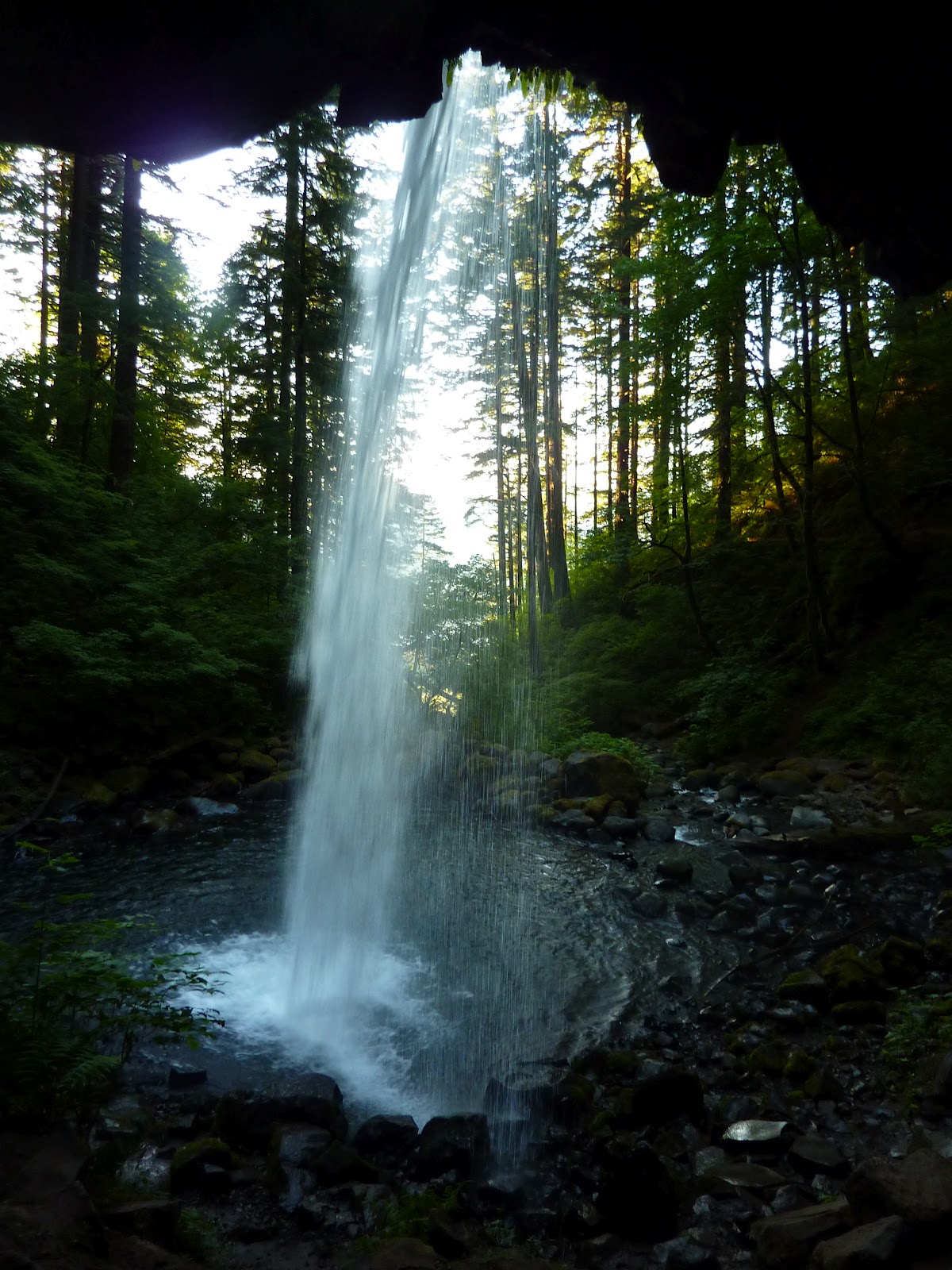


 From the saddle I walked the surprisingly difficult and far way to Plummer Peak, which is mostly a trail, but gets bushy at the end, actually requiring you climb "through" a tree and then go over a few jagged rocks for your view. Lady bugs were up there, being swarmy. I stayed for a bit admiring the swirling clouds out west over a sea of rolling hilly mountains, and Eagle Peak and its ridge, which looked like good solid rock climbing and made me wish I had done the trail. But at 3.5 miles and much more elevation gain, its a half day or more adventure. There was a fabulous pyramid down by "Cliff Lake" which sits between Plummer and Eagle. Made me want to go there. To the east are great shots of Pinnacle and the Castle, as well as big Unicorn Peak up above Snow Lakes, another popular trail. No trail goes to Unicorn, but you can bush pretty easily from the Snow Lakes, with the route obvious or so I have read and the map indicates, as well as what I could see with my own eyes.
 I worked over to Pinnacle next, which was looking more serious than I'd planned. A steep scramble. Turned into a climb for the last few hundred feet which I did not expect until looking at it. I'd read some basic info that claimed it was a scramble, class 3, but clearly that is the usual bravado of "pro" climbers, the guys who use rope, special shoes, harnesses, and who will never admit that anything was hard, fun, or worthy of their greatness. Actually, I've found most climbers are real jerks in my time, arrogant, and about the mental and emotional equivalents of pouting 14 year olds. They will sneer about everything they do in a dismissive way. And they will tell you something like Pinnacle Peak is just a scramble, class 3. Its a 5th class climb for at least 2 pitches. I found slings left there by pro climbers scared to climb down without rope aid, and I am confident that not many people solo climb that peak. Its easy 5th class. I'd say 5.5, but the scramble advice is nonsense. A scramble, 3 class, means occassional use of hands. I dare anyone to climb the route up Pinnacle with their hands in their pockets as I did on Angel's Landing at Zion. That is 3 class. Its a steep walk, with a handhold now and again. These climbers, they're the best. Ask them about Mt Everest and they'd say, "oh its hardly a climb. Don't know why I even bothered. Now Mars has some big mountains. 15 milers. And if Kelty Inc ever invents a decent deep sea climbers suit, I could probably find a challenge climbing the Atlantic Deep Sea Ridge from bottom up without a headlamp, blind, like Aqua Man"... well I had fun. And though its a soup sipping if you're used to mountains and climbing, its not for just anyone. There is no route, just pick a line and try not to die. More great views, with swirls of clouds moving in around Rainier. Headed down to make a run at The Castle, but things were steep enough that I wanted both hands and stowing my axe in the pack was still in my way, getting caught on rocks and making me do some crazy contortions to free it from snags, which put me at risk of that nemesis of many, Gravity. I dropped the axe down 10 feet and watched with some cursing as it bounced and sang down 500 feet of broken cliffs- all red, and shining in the sun. My axe is red, by the way, and shines in the sun.

 So I spent the next hour going up and down scree and nasty little crumbly cliffs, 4th class mostly (very steep, but not quite vertical) looking for the thing as I was not leaving it. Eventually found it hundreds of feet above me, dangling hidden from view except from the very spot I was standing. Couldn't see it as I climbed up, but kept a straight line and found it. That spent enough time that I gave up on The Castle. It was hot, bright, and I had other parts of the park to see. Did take the time to hack away a lot of melting ice ledges on the way down though so hikers the next day would not fall through and get a jolt if not paying attention. Skipped the Snow Lakes trail as I did not want to climb Unicorn Peak too. I regretted this later as I met some hikers who told me the lakes were lush with flowers. But the views from any Tatoosh Peak will be pretty comparable. In that regard, Plummer is the easiest to reach for most and will do just fine. If you have a car shuttle, however, the Tatoosh Traverse going from Eagle to Unicorn and down Snow Lakes would be reasonable for a day. Or start at Snow Lakes Trail and work West to Eagle Peak and trail, as you would start from a higher elevation I think. The view is always basically of the Tatoosh range you are not on, and of Rainier, which looks pretty much the same from about the entire state of Washington. I skipped Steven's Creek due to rampant ugliness that was evident from the road, and tried a short touch of the Wonderland Trail which goes 100 miles or so around Rainier. This section was very pretty and made me want to come back for more someday. This was around Box Canyon, which is a deep gorge, very pretty, which I got not one single good photograph of. A pity! Looked like a greener version of some gorges in Zion National Park, and a taller version of Avalanche Gorge in Glacier (pictured in another post on this blog). Then I went to Ohanapecosh, on the advice of some fellow travelers probably reading this right now.

Some crazy tree stumps that looked like wheels and the sun lowering on the Wonderland Trail near Box Canyon. Above, I wondered what people in Paradise were experiencing, with the clouds probably enveloping them completely. Too late in the day for anyone but an idiot to be on the summit- coming down would be slide city.


 Good advice. A beautiful old-growth forest with easy trails, The Grove of the Patriarchs especially impresses, with massive trees to rival the Sequoiahs or Redwoods of California. Also there are creek and waterfall opportunities. I played on some wet cliffs despite signs assuring me I would die if I did so. I did almost slip, so don't do likewise, unless you have good shoes and are sturdy in them. Not much more to say than that. Silver Falls is not so beautiful, but the hike is short. I drove up next towards Sunrise, but it was too late to reach it. Tried some pictures of waterfalls along the road. Most did not come out. The drive is pretty though I kept few photos. Of course, there will pro photographers setting up tripods and one actually whistled at me to let me know I was improperly infringing on his staked claim, or something. He and a friend were setting up taking hundreds of pics of a fall, and I motioned that I was going to pass by and hike to it. I then started climbing up the thing, all in under 3 minutes, and he began making angry noises. Apparently it is bad etiquette to stop the 20 clicks per minute digital photo-snapping of a pro at work, when he has an hour of button pressing ahead of him. I hate photographers. I don't consider myself one. I am an adventurer who takes pictures. This gentleman was also lucky I was in a hurry, there were others around, and I was not quite as feral as I would be within a week's time, or I might have had some words with him too. I did not even deign to sneer at him though. Wasn't near crabby enough. Below is a fallen over massive tree you can look up inside the trunk of. A grown man with kids walked right into it and made the kind of sound 5 year olds do in an ice cream parlor combo toy store for the first time. It was awesome. The tree and the guy's super enthusiastic reaction to it. I may add more pics of some trees but most did not come out.

I skipped Sunrise when I looked at the road. Steep, winding, long, and I figured, not worth it. I can only do so many slow steep roads in a week's time. So I drove on, and had a time of it looking for someplace to sleep. Chose a Walmart parking lot some town or other. Gave me time to find a replacement bandana for one I lost in Glacier. I bought 2, and promptly lost one within 2 days. I still have the other, thankfully, though as far as disasters go, losing $2 bandanas and a washcloth (the only things missing when I got home) is pretty tolerable.
I will probably have a few panoramas out of these pics on the actual website at some point soon. Have not developed those yet, but got some decent wider views of the Tatoosh range peaks. What beautiful weather! I can't promise you'll see Rainier when you go. Its often masked by clouds.

No comments:
Post a Comment