Sorry to my very few readers, but I am having a really hard time getting motivated to write about this recent trip.
Not that it was a bad trip. It was great. I keep remembering parts of it and wondering if I really did all that in just 17 days, which included an oil change, say 10 grocery store runs for little things I forgot, 2 trips to Fairhaven for good meals, all that hiking, so much driving (60 hours in a car, seriously, which makes 160 miles over 17 days, when pro-rated to 12 actual full days of daylight all the more impressive), and so many different spots. I have gone through photos now, at least in part. I still have about 800 pics on my computer, most of those good, though none what I would call great. I was expecting a few great ones. So I am disappointed. Forests are hard to get the right lighting in, especially when moving fast and constantly. Either you hit a spot at the right second or else miss the picture, but that is how I've always done things. It works better in Utah though where skies change more slowly (I've noticed now in Montana and Washington that storms move in faster and clouds just change more in general; it is much less predictable) and I am a sage about weather. In Utah I can predict on a trip the breaking of a storm often to within minutes. "Oh," I once said casually to a friend tagging along, "the storm will drizzle for 45 minutes around 2:15 pm, and then come hard for an hour around 3, so we'll want to be down by then", and that happened exactly! I looked like a genius, you might imagine. In Washington, I said to one fellow that I thought some fog would hang about until noon and not five minutes later I was applying sunscreen. I beat it out of there quick so I wouldn't have to shrug to him, "when you're wrong, you're wrong, you know?"
Anyhow, I was in a real funk getting home for days. I was still knife-itchy and crabby. I wanted to punch everything and my body stiffened up to reveal some other minor little, not injuries, but aches. I had a bone knob in my right shoulder about two times larger than in the left and sticking out, probably from sleeping on the ground. I can't sleep on my left side on the ground as if I do my old bad left elbow can't be straightened next morning, which is inconvenient. And I had some bruises I did not know about, plus cuts on my feet, and the like. But feeling back to normal, which is just right, as I'll be heading out in a week again and it will take some days to adjust to the grime and the grind again.
So Mt St Helens was not on my itinerary but sleeping at a rest area in Washington after a single day 12 hour drive to Portland which included a brief 4 mile 5 waterfall evening extravaganza to stretch the legs- I did too much running which wore me out a bit for the next day- I was reading some excellent area literature and decided St Helens was close enough to be all but essential. I did not climb the South side of the mountain. That requires a $22 pricey permit and months of planning as they are limited in number and sell out in advance, but I did hike on both the North and South of the mountain. I will detail my trails.

I started in the Ape Cave around 7 am, which I knew nothing about, and still do not know why it is named "Ape Cave". But I sensed enough to take all the lights I had, a flashlight and headlamp, neither of which was much aid. The ape cave is a lava tube underground for over a mile, and you descend in to this cold, dripping, light-less echoing subway, usually with a ranger and a huge lantern and wander about over smooth but still knobby floors and walls shivering and probably in most cases laughing with chums and family to not be creeped out. If there at 7 am, you are hours ahead of rangers, alone, and will be creeped out. I had to use all the powers of the Enlightenment to remind myself no one was following me, no large animals could or would try to survive down there, bats would avoid my light, and that I need not turn around unless I wanted to prove I was a coward or a fool. Well I also should have read signs more careful. There is only one main entrance stairwell and the South main "trail" feeds into a shrinking stooping dead end and you retrace steps. So I was down in there for an hour. The ranger who was ticketing me when I came out, for not paying a $5 parking fee (my argument: "I don't have a pen, but see I left $5 on the dashboard to prove I wanted to pay, but couldn't fill out your complex government fee envelope so that the money does me no good." His rebuttal: "You have to pay $5 and fill out an envelope to park here. It only takes me 5 minutes to write a $55 ticket. My answer: "Oh let me keep looking for a pen then, no don't loan me yours.") I kid a little. He was a nice guy. Told me where to go next and seemed to want to back away instinctively and not piss off anyone who would descend into the Ape Cave alone with bad lighting so early on a cold morning. Wise choice, perhaps.

Next on this ranger's tip I went to the Lava Canyon area. He told me the highlight was a suspension bridge and brother, he wasn't kidding. When the highlight of your trail is a man-made wooden shaking bridge, you know you're on government land. These people love bridges, and roads, and expensive structures of any kind. Then whining about how broke they are. Lava Canyon is a mostly-recovered area on the South of St Helens where a single stream of lava burned out a gorge with waterfalls and black smooth domes which were fun to climb, I might add. The waterfall is ruined by, you won't believe this, another bridge! Right over the thing so its all but impossible to admire it. Unless you have a goofball child with you who wants to do goofball things over a waterfall, and then the bridge is in the perfect place. The trail is brief and easy and there are some good viewpoints, though the best I thought was on...a bridge...a driving bridge with no parking or walkway, so I just threw on the flashers nearby and walked onto the bridge, and sure enough a ranger came by, and looked like he wanted to yell at me, but perhaps it was too early, or there weren't enough witnesses to see him berating me like the bad man he is, or maybe it was the large bowie knife on my side, but he drove on and let me take my picture in peace. Thanks National Forest Service. You guys are great.


Next up, a trip to buy an annual Northwest Forest Pass (which I'd wanted before being harassed into buying a day pass) for a mere $30. A great deal, as it covers much of Washington. I stopped and had to wait for a family of uber-tourists trying to pry secrets from a ranger, so they could avoid...tourists! Probably they hiked for a few minutes and left to go have lunch. If not, then a bear ate them within the hour, I am sure. But I strayed over to the Info Booth girl because, well let's use multiple choice as a callback to school days: a) she was cute, b) I was bored, c) she asked me if she could help me with anything, d) all of the above. Here is an actual transcript of our conversation: Me: "Oh well maybe, I want to buy a Northwest Annual Parking Pass." She: "Oh well I'm just the Info Booth, the cash register is over there with Jim, so you will have to talk to him." Me: "Okay. Have you ever hiked to Loowit Falls?" She: "What falls?" Me: "Loo. Wit. L-O-O-W-I-T, over on the Windy Ridge side, its a falls coming out of the crater I saw on a map a few minutes ago. I was wondering if its worth it." She: "Oh! Is there a falls coming out of the crater? Actually I don't think there are any falls up on the North side, but then, I'm not sure. I've never hiked that area, but there is a lot of stuff to do around here, so maybe there is. I wouldn't be surprised. Did you hike all the way into the crater then?" Me: "Um. No, see I was looking for info about it, I was just thinking about doing it." She: "Well I don't think you're allowed to hike into the crater." Me: "Oh okay, then thanks. I am going to go get my pass now." She: "Well have fun."


You can't make this stuff up. I bought my pass for $30, a great deal. Which I will keep reminding myself because had I bought it the next day on August 1, it would have been good through August 31, 2013 instead of July 31, 2013. See it goes through the end of the month. No one mentioned that while I was buying it. Would have been nice to know since I was already covered for July 31, 2012. Ah Jim, I am going to only say, that I still got, for $30, a great deal. Through my teeth.
Next I drove to Windy Ridge along one of Washington's many annoying roads. Some motorcyclists nearly hit me on a hairpin high elevation turn (20 mph speed limit: my speed 24 mph) going near 70 mph. Clearly they were enjoying the road more than I was able in my vehicle. I would have liked to go faster. But I also wanted to do as little whimpy dying as I could that day. I wasn't even mad. Just jealous of the cyclists. However when I got out of my car 20 minutes later and 4 middle aged dorks in racing jumpsuits were talking excitedly about some "jerk" they almost hit blind on a turn doing like "twenty" ("come on bro! Jeez!") I began to get riled. But I was still civilized at this point of the trip. Another week and I might have had words with them, and by words I mean, picked a fight with all 4, because that would have been close to a fair fight. I still would have won easily, but could anyone have blamed me when the cops and rangers came? Officer: that man picked a fight with 4 bikers and beat them senseless for no reason! See, its just not the sort of storyline anyone believes. Biker gang = guilt. I've seen the 1950s movies. I'd have walked scott free.

I found at the parking area, one heck on an ugly and not-worthy overlook. For a good view after your long and winding drive, you needs head around an ugly hillish mountain (the logging road) or go above it on a steep but brief trail up some steps that most take. A ranger of the charming active type was giving an interesting lecture on recovery of the area over the past 32 years and was just finishing, so I went to read the map and she began offering incredibly pertinent advice about trails in the area, including distances, difficulty, most worthwhile, and those in season right then (meaning wildflowery). A ranger who hikes?! She must be one of the summer rangers between semesters of college. I met one of those in Idaho and we had pleasant and useful conversation and I met another later in the North Cascades Park who bumped into me 4 different times and always seemed amused that I was seemingly everywhere in the park so quickly. Well she and I agreed Loowit Falls was for me. Its for anyone who's up to it, and those middle age big-talking bikers were not, so it fell on me to enjoy the beauty of a waterfall coming out of a volcanic crater that day. And probably for the next few as the trail I expect sees little usage excepting weekends.

The trail can be done as a loop, in any of several ways, and can connect to trails going right down to Spirit Lake and then back up to the overlook. I'd arrange that as the first 2 miles and last 2 miles I took were hot, and on an old logging road. There are plenty of those in Washington. Now, do not think I am against logging companies or logging roads. I think logging as done in Washington seems to be stewarded responsibly and it does keep families working and living. Forests do die, if you let them, anyway. So keep on logging. But a theme of my trip was that I would check my mirror, see no one, drive amicably along for 1/3 of a second, hear something close and loud and terrifying, look in the mirror, see a logging truck about to hit me, then swerve into oncoming traffic and pass me viciously at 90 mph in a school zone on a curve while baby seal pups die in terror beneath the wheels. I exaggerate only a little. Logging trucks so far as I could tell do not have to obey any laws of man or God, including gravity. They do what they want. It took me until the Olympic Peninsula two weeks later to learn the proper and surest course of action: wait for a logging truck to come, slow down, and start making it hard to pass. Do this until the driver takes out his shotgun and flashes you his License to Kill. Then let the a-hole pass. This trail is not an active logging trail though, so you only have to fear cyclists. Sometimes worse than logging trucks. Most seemed confused why anyone would be on this ugly road on foot. I was too until the trail began where the logging road ends. (Below: Smoke coming from the crater, the trail turning back South and uphill from near Spirit Lake to head into the crater area, and in the third pic, if you enlarge it, you can see Loowit Falls on the foreground black dark slopes, so there is no mystery where you are heading)


The trail for the whole loop is ugly. Really ugly. But its beautiful and interesting in the sense that if you keep reminding yourself you are not in Arizona, then there is wonder here. Little oases have sprung up along creek flows through big volcanic blocks, wild flowers bloom everywhere, baby pines seemingly oblivious or defiant to reality pop up in dry wastes as if a little boy in a driveway dribbling a basketball off his foot might scowl to a stranger, "me be in the NBA one day". It was cute, if you don't focus on how in 2 years it will be too big to find enough water and will fall down dead as a stone. Across Spirit Lake the blast zone is recovering faster and a whole massif of rolling forested peaks stand up green and lovely. To the east is an untouched pine forest through deep ravines to contrast with, and remembering my trip that morning to the South, I knew that sweet pine scents and twittering birds were once the norm here. The mountain itself is blown wide open up close. It looks flat, easy to climb. The crater seems near enough to touch especially as the loop trail heads to the falls and straight into the crater, seemingly. Up above, the ugly doughnut of a mountain that was once beautiful and huge smokes from its active lava dome. Which is cool more than unnerving, though if it smoked any more, it might make one walk a little faster. I found several falls actually. Loowit is a double spray, not approachable, and the cliffs around it are not practicably climbable. Fill your shoes with ash if you do not believe me, and good luck scrambling down. I gave it up and settled for the poorish view. But another fall just West can be reached by following a creek a short ways right up to a big spraying tumble, not named or marked on map. With the added distance, my loop was perhaps 12 miles. 11 is the official loop. It gets hot in the afternoon, though there is water to purify. A good creek east of the falls is your best bet for not clogging your filter with ash. Do not try to go into the crater. It is against the rules, will slow recovery of the area, will be tedious and torturous due to the nature of rock, and might be dangerous. Below are pics approaching a couple of falls, and the oasis where I took water after ignoring every previous creek.


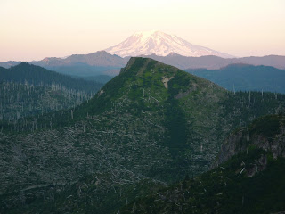
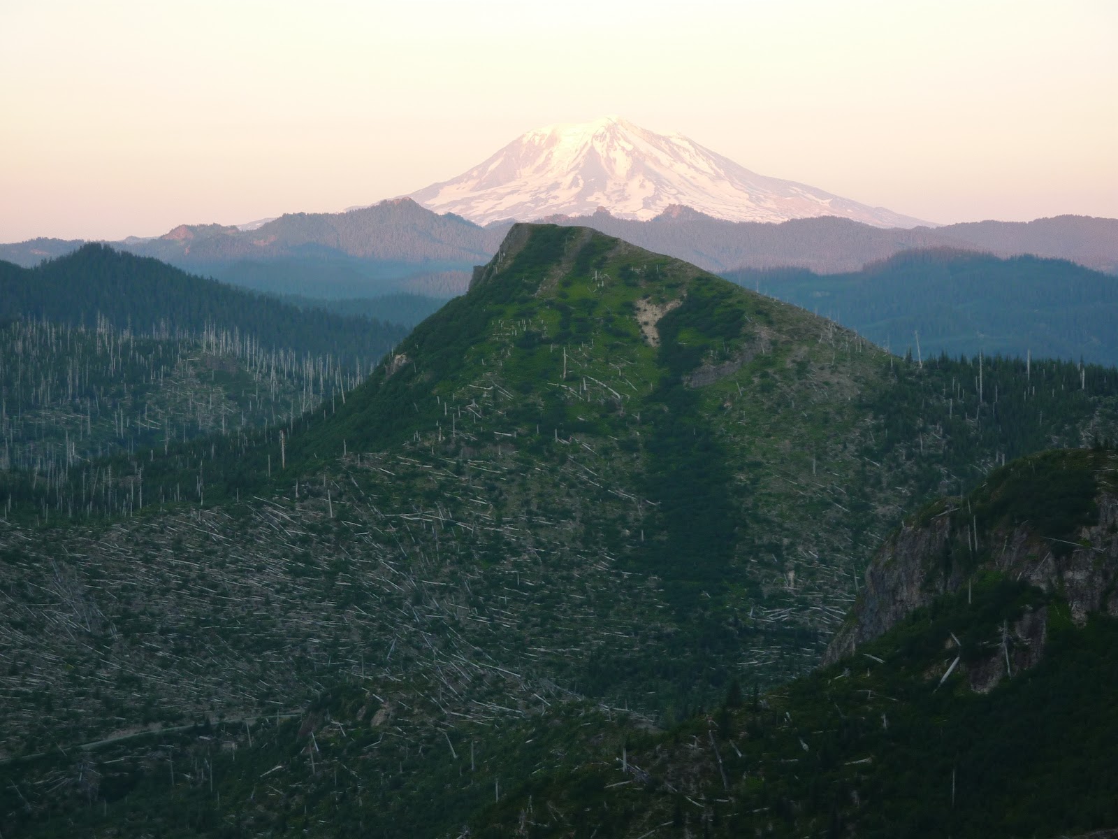
I got back in under 4 hours which was great as it gave me time to cool off, recover, and then drive a short distance to the parking for Norway Pass trailhead. This is also in Windy Ridge, though you turn off onto a dirt spur, not advisable for 2 wheel drive cars according to signage, though to the Norway Pass TH it is fine. This is a morning trail, and will be sunscorched in evening. I ate and fattened up and rested and rehydrated and mused if I wanted to use up another half day on Mt St Helens when it was not in my plans to begin with, and then watched the setting sun sink, and as shadows covered the trail, I decided to make a push before dark. A couple was there with me and had already tented up in the parking lot, eventually deciding to stop their coyness with me and that I was not an undercover ranger. I seemed to inspire a lot of undercover ranger suspicion on this trip. More examples to come in their proper time. The trail is easy and a treat. The grade is level and no uneccessary switchbacks exist. You make Norway Pass in 2.2 miles, very quick and easy. I think I hit it in 30 minutes and had time to explore. From the pass you can continue to Mount Margaret, the prime peak on the pretty green rolling massif I mentioned earlier at the edge of the blast zone, which adds 4 miles or so, or a trail that heads towards Spirit Lake. Neither was plausible for me this night. So I hung out and snapped pics from my ranger friend's favorite spot. You can see the crater of Helens, Spirit Lake, still after 32 years 1/3 covered with a sheet of melted fused decaying forest logs that look deceptively like snow, shattered tree limbs, sprouting wild flowers and knocked down hills of still barren slopes, though grassy. To the east is Mt Adams glowing red at sunset or sunrise. On my decent, I found signs of elk and heard large noises nearing me as I neared the parking lot. I made some Indian calls and rapped with my trusty alpine axe on rocks. Back in the parking lot, my friends took a break from their tent tickle fight (or something that was producing a lot of giggling) to ask if I'd seen the elk family. I said no but that I'd heard Papa coming my way) to tell me there was plenty of room on their patch of grass for another tent. But laziness and shyness kept me in my car, sleeping till morning.
Pulled out early to drive to Rainier next morning. The couple was heading to Mt Margaret and I was jealous as there were early morning clouds isolated and low, so that the peaks were all sticking out of a shrouded world. Oh well, I'd worried the morning might obscure the view, and probably the lake would have been hidden, and I did the trail at the suggestion of that charming, active ranger who said it was the coolest and most complete view of the area in all the monument. (All the pics below are Norway Pass except for first on the left; that faces East from the logging road and shows what the area once looked like, as some the forest shots above from Lava Canyon do)


Johnson Overlook is possibly the only other great view. I skipped it. The road is isolated and long, but that is the spot to hit if you need accessible (wheelchair) viewing. I saw a few other people that day, but very few on any of the trails. I did 21 miles in all, on 4 different trails, all very unique experiences. I recommend each, and others in the area. Climbing the peak is probably cool too, though my mountaineering in the Cascades book makes fun of it as the "world's steepest tourist line". But you can look down into the crater and on a winter day especially it would be choice, with the lava dome smoldering and smoking below. Or just buy a postcard and save the 8 hours. Below is my favorite picture of a baby pine tree trying its mightiest to be a forest. I forgot to post it earlier. This is heading down to Spirit Lake. The next pic is a peak easily tabbed while at Norway Pass. I passed on it, deciding I was so close to 100 peaks, that I wanted to start only ascending "dignified" impressive mountains. Which is stupid by the way. As I could have easily had 16 or 17 peaks and be over 100 now after that trip. And I'd be nowhere near 100 without the dud peaks. Mountains are hard. Here is another wilderness rule: If you can summit a mountain and return in less than an hour, you do it, no matter how tired, pressed for time, worried about weather, or ugly it may be. Don't count on tomorrow or the next mountain.


The drive into and around Mt St Helens was fun at first, going through old-fashioned woodsy towns with expansive yards and secluded old-style homes, reminding me of Illinois and my childhood in the long long ago, before strip malls, stucco, and cardboard architecture which my architect brother could sulk to you about more artfully than I, but it gets old in a hurry. Lots of areas are patched as need requires, where slides occurr, and must be taken slowly, no easy feat when moving downhill at 50 mph when you see a sign that reads (A Washington specialty: Next turn 20 mph, 100 feet before you hit a bump). I enhanced the drive by listening to Alan Hovanhess, Pacific Northwest composer and especially his decent "Mt St Helens Suite".
It would be interesting to go and do the trails every 10 years and see how things have changed. I don't know that year to year any difference would be noticeable. I am very glad I squeezed this trip in though. It was my most mileage of any single day, and not a great idea to do so much in one, at such a high pace, as it started to wear me down too early on the trip, but I'm much richer for having seen the area. And it was a great day, with better pictures than I expected for the amount of sun I was dealing with and being out at the wrong time for many of those miles. Coming up by tomorrow: my next day at Mt Rainier.


 You can't make this stuff up. I bought my pass for $30, a great deal. Which I will keep reminding myself because had I bought it the next day on August 1, it would have been good through August 31, 2013 instead of July 31, 2013. See it goes through the end of the month. No one mentioned that while I was buying it. Would have been nice to know since I was already covered for July 31, 2012. Ah Jim, I am going to only say, that I still got, for $30, a great deal. Through my teeth.
 I found at the parking area, one heck on an ugly and not-worthy overlook. For a good view after your long and winding drive, you needs head around an ugly hillish mountain (the logging road) or go above it on a steep but brief trail up some steps that most take. A ranger of the charming active type was giving an interesting lecture on recovery of the area over the past 32 years and was just finishing, so I went to read the map and she began offering incredibly pertinent advice about trails in the area, including distances, difficulty, most worthwhile, and those in season right then (meaning wildflowery). A ranger who hikes?! She must be one of the summer rangers between semesters of college. I met one of those in Idaho and we had pleasant and useful conversation and I met another later in the North Cascades Park who bumped into me 4 different times and always seemed amused that I was seemingly everywhere in the park so quickly. Well she and I agreed Loowit Falls was for me. Its for anyone who's up to it, and those middle age big-talking bikers were not, so it fell on me to enjoy the beauty of a waterfall coming out of a volcanic crater that day. And probably for the next few as the trail I expect sees little usage excepting weekends.
 The trail can be done as a loop, in any of several ways, and can connect to trails going right down to Spirit Lake and then back up to the overlook. I'd arrange that as the first 2 miles and last 2 miles I took were hot, and on an old logging road. There are plenty of those in Washington. Now, do not think I am against logging companies or logging roads. I think logging as done in Washington seems to be stewarded responsibly and it does keep families working and living. Forests do die, if you let them, anyway. So keep on logging. But a theme of my trip was that I would check my mirror, see no one, drive amicably along for 1/3 of a second, hear something close and loud and terrifying, look in the mirror, see a logging truck about to hit me, then swerve into oncoming traffic and pass me viciously at 90 mph in a school zone on a curve while baby seal pups die in terror beneath the wheels. I exaggerate only a little. Logging trucks so far as I could tell do not have to obey any laws of man or God, including gravity. They do what they want. It took me until the Olympic Peninsula two weeks later to learn the proper and surest course of action: wait for a logging truck to come, slow down, and start making it hard to pass. Do this until the driver takes out his shotgun and flashes you his License to Kill. Then let the a-hole pass. This trail is not an active logging trail though, so you only have to fear cyclists. Sometimes worse than logging trucks. Most seemed confused why anyone would be on this ugly road on foot. I was too until the trail began where the logging road ends. (Below: Smoke coming from the crater, the trail turning back South and uphill from near Spirit Lake to head into the crater area, and in the third pic, if you enlarge it, you can see Loowit Falls on the foreground black dark slopes, so there is no mystery where you are heading)


No comments:
Post a Comment